IMAGES TAKEN NEAR TO
Greenfields, MAIDENHEAD, SL6 1BD
Introduction
This page details the photographs taken nearby to Greenfields, SL6 1BD by members of the Geograph project.
The Geograph project started in 2005 with the aim of publishing, organising and preserving representative images for every square kilometre of Great Britain, Ireland and the Isle of Man.

There are currently over 7.5m images from over14,400 individuals and you can help contribute to the project by visiting https://www.geograph.org.uk
Image Map
Images are licensed for reuse under creativecommons.org/licenses/by-sa/2.0
Notes
- Clicking on the map will re-center to the selected point.
- The higher the marker number, the further away the image location is from the centre of the postcode.
Image Listing (97 Images Found)
Images are licensed for reuse under creativecommons.org/licenses/by-sa/2.0
Image
Details
Distance
1
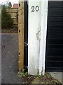
Benchmark on garage of #20 Braywick Road
Ordnance Survey cut mark benchmark described on the Bench Mark Database at http://www.bench-marks.org.uk/bm36246
Image: © Roger Templeman
Taken: 10 Dec 2010
0.08 miles
2
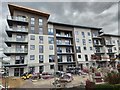
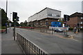
New Flats in Maidenhead
The final finishing and landscaping of a block of flats in a development.
Image: © James Emmans
Taken: 28 Jul 2020
0.11 miles
5

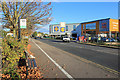
Redrow Housing Development
The Lofting is near the railway station. It seems to be built on a business park, this type of development is becoming normal with the need for more housing without using up green belt land.
Image: © James Emmans
Taken: 28 Jul 2020
0.16 miles
6
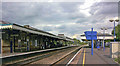
Maidenhead station, 2006
View east, towards London Paddington: ex-GWR Paddington - Reading etc. main line, junction of the branch to Marlow and (until 1970) to High Wycombe.
Image: © Ben Brooksbank
Taken: 26 Aug 2004
0.16 miles
8

Benchmark on brick pillar on side of #42 Braywick Road
Ordnance Survey cut mark benchmark described on the Bench Mark Database at http://www.bench-marks.org.uk/bm36247
Image: © Roger Templeman
Taken: 10 Dec 2010
0.17 miles