IMAGES TAKEN NEAR TO
Howarth Road, MAIDENHEAD, SL6 1AP
Introduction
This page details the photographs taken nearby to Howarth Road, SL6 1AP by members of the Geograph project.
The Geograph project started in 2005 with the aim of publishing, organising and preserving representative images for every square kilometre of Great Britain, Ireland and the Isle of Man.

There are currently over 7.5m images from over14,400 individuals and you can help contribute to the project by visiting https://www.geograph.org.uk
Image Map
Images are licensed for reuse under creativecommons.org/licenses/by-sa/2.0
Notes
- Clicking on the map will re-center to the selected point.
- The higher the marker number, the further away the image location is from the centre of the postcode.
Image Listing (60 Images Found)
Images are licensed for reuse under creativecommons.org/licenses/by-sa/2.0
Image
Details
Distance
1
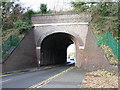
Railway bridge, Forlease Road, Maidenhead
Image: © Andrew Smith
Taken: 1 Jan 2006
0.03 miles

3
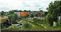
York Stream, Maidenhead
From the railway line. The old water channel from and to the Thames curves past an industrial estate.
Image: © Derek Harper
Taken: 3 Jun 2019
0.07 miles
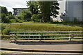
6
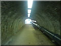
Foot Tunnel under the Railway
The London-Reading line is very wide at this point, close to Maidenhead station.
Image: © Martyn Davies
Taken: 26 Sep 2006
0.09 miles
7
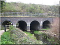
Maidenhead: York Stream
The four flood arches allowing York Stream to flow under the main line railway embankment.
Image: © Nigel Cox
Taken: 19 Apr 2006
0.09 miles
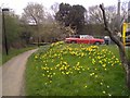
9
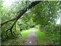
Footpath alongside The Cut
The Cut connects to the River Thames and retains public navigation rights, though it is impractical for boats to pass through the sections in Miadenhead today as they are silted up and overgrown. The old channel leaves the Thames just above Cliveden and eventually rejoins it just below Bray Lock by the Marina. In the centre of Maidenhead a green walk has been created alongside The Cut, as seen here between the trading estate at Stafferton Way and Green Lane.
Image: © Marathon
Taken: 22 Sep 2013
0.11 miles
10
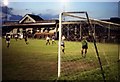
Maidenhead United's ground at York Road
Image: © Steve Daniels
Taken: 27 Mar 2009
0.12 miles