IMAGES TAKEN NEAR TO
Maypole Road, MAIDENHEAD, SL6 0NF
Introduction
This page details the photographs taken nearby to Maypole Road, SL6 0NF by members of the Geograph project.
The Geograph project started in 2005 with the aim of publishing, organising and preserving representative images for every square kilometre of Great Britain, Ireland and the Isle of Man.

There are currently over 7.5m images from over14,400 individuals and you can help contribute to the project by visiting https://www.geograph.org.uk
Image Map
Images are licensed for reuse under creativecommons.org/licenses/by-sa/2.0
Notes
- Clicking on the map will re-center to the selected point.
- The higher the marker number, the further away the image location is from the centre of the postcode.
Image Listing (13 Images Found)
Images are licensed for reuse under creativecommons.org/licenses/by-sa/2.0
Image
Details
Distance
1
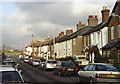
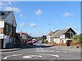
Lent Rise, Burnham (Bucks)
Terraced housing such as this was built towards the end of the nineteenth century and is fairly typical of the Lent Rise area of Burnham. This is Milner Road looking north.
Image: © David Kemp
Taken: 12 Jan 2006
0.07 miles
2
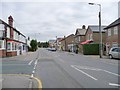
Eastfield Road, Lent Rise, at Milner Road junction
Image: © Kevin White
Taken: 22 Sep 2009
0.07 miles
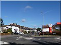
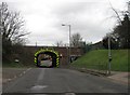
8
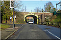
Railway bridge over Lent Rise Road, Burnham
The Great Western main line crosses.
Image: © Robin Webster
Taken: 8 Dec 2019
0.13 miles
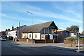
10
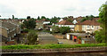
Green Close, Taplow
Houses and garages at the end of a cul-de-sac, seen from the railway.
Image: © Derek Harper
Taken: 3 Jun 2019
0.17 miles