IMAGES TAKEN NEAR TO
Taplow Road, MAIDENHEAD, SL6 0ND
Introduction
This page details the photographs taken nearby to Taplow Road, SL6 0ND by members of the Geograph project.
The Geograph project started in 2005 with the aim of publishing, organising and preserving representative images for every square kilometre of Great Britain, Ireland and the Isle of Man.

There are currently over 7.5m images from over14,400 individuals and you can help contribute to the project by visiting https://www.geograph.org.uk
Image Map
Images are licensed for reuse under creativecommons.org/licenses/by-sa/2.0
Notes
- Clicking on the map will re-center to the selected point.
- The higher the marker number, the further away the image location is from the centre of the postcode.
Image Listing (14 Images Found)
Images are licensed for reuse under creativecommons.org/licenses/by-sa/2.0
Image
Details
Distance
1
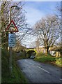
Railway over-bridge, Taplow Road
Reckoning in railway terms, this is the second overbridge when heading east from Taplow station. The line it carries is the old GWR main-line out of Paddington. I can't say for certain that this was the structure Brunel built for the broad-gauge, but in style and materials it matches many of the better known examples.
Image: © Stefan Czapski
Taken: 14 Jan 2014
0.09 miles
2
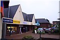
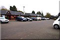
Retail units at The Bishops Centre
The Bishops Centre is to be rebuilt with Tesco taking the largest unit. Many of the small businesses will have to relocate.
Image: © Steve Daniels
Taken: 11 Nov 2011
0.16 miles
3
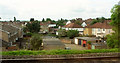
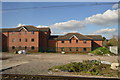
Green Close, Taplow
Houses and garages at the end of a cul-de-sac, seen from the railway.
Image: © Derek Harper
Taken: 3 Jun 2019
0.16 miles
5
Retail units at The Bishops Centre
The Bishops Centre is to be rebuilt with Tesco taking the largest unit. Many of the small businesses will have to relocate.
Image: © Steve Daniels
Taken: 11 Nov 2011
0.18 miles
6
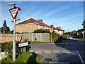
Hag Hill Lane
Nothing special as a road, but a great name.
Image: © Des Blenkinsopp
Taken: 15 Nov 2013
0.18 miles
8
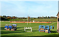
Rugby Posts and Rollers
Sports ground near Taplow station.
Image: © Des Blenkinsopp
Taken: 15 Nov 2013
0.22 miles
9
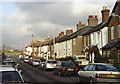
Lent Rise, Burnham (Bucks)
Terraced housing such as this was built towards the end of the nineteenth century and is fairly typical of the Lent Rise area of Burnham. This is Milner Road looking north.
Image: © David Kemp
Taken: 12 Jan 2006
0.22 miles
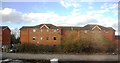
10

Housing near Lent Rise
The housing on Hanbury Close consists of short terraces; these, at right angles to the close, back onto countryside. The more distant housing is on Milner Road and Lent Rise Road.
Image: © Derek Harper
Taken: 19 Nov 2010
0.22 miles