IMAGES TAKEN NEAR TO
Bath Road, MAIDENHEAD, SL6 0AR
Introduction
This page details the photographs taken nearby to Bath Road, SL6 0AR by members of the Geograph project.
The Geograph project started in 2005 with the aim of publishing, organising and preserving representative images for every square kilometre of Great Britain, Ireland and the Isle of Man.

There are currently over 7.5m images from over14,400 individuals and you can help contribute to the project by visiting https://www.geograph.org.uk
Image Map
Images are licensed for reuse under creativecommons.org/licenses/by-sa/2.0
Notes
- Clicking on the map will re-center to the selected point.
- The higher the marker number, the further away the image location is from the centre of the postcode.
Image Listing (152 Images Found)
Images are licensed for reuse under creativecommons.org/licenses/by-sa/2.0
Image
Details
Distance
3
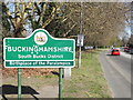
Buckinghamshire, South Bucks District
Signs on the A4 Bath Road welcoming motorists to Buckinghamshire and to Taplow. Note the reference to the Paralympics - these had their roots in a gathering of WW2 veterans at Stoke Mandeville Hospital, Aylesbury, Buckinghamshire in 1948.
http://en.wikipedia.org/wiki/Paralympic_Games
Image: © Colin Smith
Taken: 28 Mar 2012
0.05 miles
4
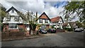
Ellington Road
Large detached houses close to the River Thames.
Image: © James Emmans
Taken: 4 May 2021
0.08 miles
5
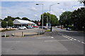
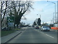
Volkswagen dealer in Taplow
Windrush a Volkswagen dealership on the A4 near Taplow.
Image: © Philip Halling
Taken: 6 Aug 2011
0.08 miles
6

Skindles Hotel
The whole of this white building is the former Skindles Hotel, where the famous and infamous met for many years (Edward VII when Prince of Wales, Winston Churchill, Princess Margaret in her racy heyday, the Rolling Stones to name but a few) until it closed around the late 70s/early 80s and as a listed building has remained boarded since due to lack of interest. However serious plans are now being proposed - this could be one of the last pictures!!
Image: © Kevin White
Taken: 25 Sep 2009
0.09 miles
7

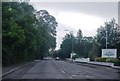
Bath Road (A4) towards Maidenhead
Nearly upended by an idiot on an E-Scooter.
Image: © JThomas
Taken: 25 May 2022
0.10 miles
9
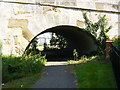
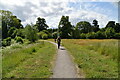
River Thames Path under Maidenhead
The Thames Path National Trail goes under Maidenhead Bridge, then right, right and right again to use the pavement over Maidenhead Bridge. It's clever as it means walkers don't have to cross the busy A4, Great West Road.
Image: © Sean Davis
Taken: 28 Jul 2007
0.10 miles
10
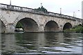
Maidenhead Bridge
This is the road bridge, carrying the A4 Bath Road, across the Thames from Maidenhead (left) to Taplow (right). It was built in 1772 and was a toll bridge until 1903. Wikipedia has more information here http://en.wikipedia.org/wiki/Maidenhead_Bridge
Image: © Graham Horn
Taken: 24 Aug 2008
0.11 miles