IMAGES TAKEN NEAR TO
Liddell Way, ASCOT, SL5 9UZ
Introduction
This page details the photographs taken nearby to Liddell Way, SL5 9UZ by members of the Geograph project.
The Geograph project started in 2005 with the aim of publishing, organising and preserving representative images for every square kilometre of Great Britain, Ireland and the Isle of Man.

There are currently over 7.5m images from over14,400 individuals and you can help contribute to the project by visiting https://www.geograph.org.uk
Image Map
Images are licensed for reuse under creativecommons.org/licenses/by-sa/2.0
Notes
- Clicking on the map will re-center to the selected point.
- The higher the marker number, the further away the image location is from the centre of the postcode.
Image Listing (10 Images Found)
Images are licensed for reuse under creativecommons.org/licenses/by-sa/2.0
Image
Details
Distance
1
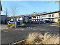
Seats and Play Area
Several carved wood features are on this patch of open land called Allens Field which is in between two residential areas.
Image: © Des Blenkinsopp
Taken: 19 Jan 2017
0.06 miles
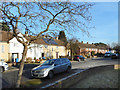
2
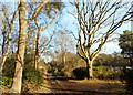
Public Footpath along a Track
This actually looks like a footpath. A lot of the marked public rights of way round here are just along ordinary roads.
But then, a lot of the ordinary roads round here are private.
Whatever. It all seems to work out...
Image: © Des Blenkinsopp
Taken: 19 Jan 2017
0.11 miles
3
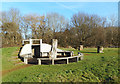
Wooden Figure on the Common
Another view of this unusual carving in the middle of a small country park on the edge of Ascot.
Image: © Des Blenkinsopp
Taken: 19 Jan 2017
0.14 miles
4
Corner of Bouldish Farm Road
Junction with Carroll Crescent.
Image: © Des Blenkinsopp
Taken: 19 Jan 2017
0.15 miles
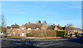
5
Bouldish Farm Road
Suburban street near Ascot station.
Image: © Des Blenkinsopp
Taken: 19 Jan 2017
0.15 miles
6
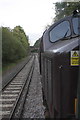
Heading south from Ascot
The overbridge carries a road track from South Ascot into Whiteladies Park.
The hazard warning of overhead electric wires on the nose of the Class 37 locomotive seems out of place on a third-rail electrified line.
Image: © Roger Templeman
Taken: 22 Oct 2011
0.16 miles
7
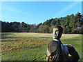
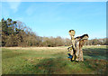
Carving on the Common
A wooden figure in the middle of a bit of park and woodland on the edge of Ascot.
Image: © Des Blenkinsopp
Taken: 19 Jan 2017
0.18 miles
8
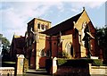
All Souls, South Ascot
Grade 2* listed building erected in 1896.
Image: © Michael FORD
Taken: Unknown
0.22 miles
9
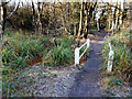
Footpath Bridge in the Woods
This square is mostly residential apart from a strip of woodland which is possibly too wet for development.
The footpath through here is on a low causeway, with pools of water on both sides and a sluggish small stream doing a not very good job of drainage.
Image: © Des Blenkinsopp
Taken: 19 Jan 2017
0.22 miles