IMAGES TAKEN NEAR TO
Armitage Court, ASCOT, SL5 9TA
Introduction
This page details the photographs taken nearby to Armitage Court, SL5 9TA by members of the Geograph project.
The Geograph project started in 2005 with the aim of publishing, organising and preserving representative images for every square kilometre of Great Britain, Ireland and the Isle of Man.

There are currently over 7.5m images from over14,400 individuals and you can help contribute to the project by visiting https://www.geograph.org.uk
Image Map
Images are licensed for reuse under creativecommons.org/licenses/by-sa/2.0
Notes
- Clicking on the map will re-center to the selected point.
- The higher the marker number, the further away the image location is from the centre of the postcode.
Image Listing (20 Images Found)
Images are licensed for reuse under creativecommons.org/licenses/by-sa/2.0
Image
Details
Distance
1
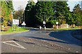
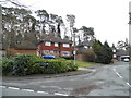
Many signs at crossroads
The camera is on the B3020 and the major road is the A330.
Image: © Shazz
Taken: 30 Nov 2014
0.09 miles
2
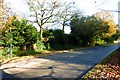
Brockenhurst Road going east towards the B3020
Image: © Shazz
Taken: 30 Nov 2014
0.10 miles
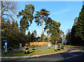
5
Murray Court at the junction of St Mary's Hill
Image: © David Howard
Taken: 1 Feb 2015
0.13 miles
6
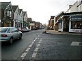
Sunninghill High Street......
.....from the phone box at St Michael's School
Image: © Dave Draycott
Taken: Unknown
0.13 miles
7
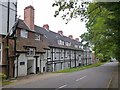
Macdonald Berystede Hotel and Spa
In Bagshot Road, Sunninghill.
Image: © David960
Taken: 31 May 2014
0.15 miles
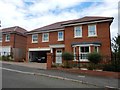
9
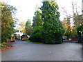
Two entranceways by the A330
The one on the right is for an hotel and spa.
Image: © Shazz
Taken: 30 Nov 2014
0.16 miles
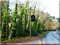
10
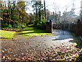
Path passes large gates just off Brockenhurst Road
Image: © Shazz
Taken: 30 Nov 2014
0.18 miles