IMAGES TAKEN NEAR TO
Cross Road, ASCOT, SL5 9RU
Introduction
This page details the photographs taken nearby to Cross Road, SL5 9RU by members of the Geograph project.
The Geograph project started in 2005 with the aim of publishing, organising and preserving representative images for every square kilometre of Great Britain, Ireland and the Isle of Man.

There are currently over 7.5m images from over14,400 individuals and you can help contribute to the project by visiting https://www.geograph.org.uk
Image Map
Images are licensed for reuse under creativecommons.org/licenses/by-sa/2.0
Notes
- Clicking on the map will re-center to the selected point.
- The higher the marker number, the further away the image location is from the centre of the postcode.
Image Listing (8 Images Found)
Images are licensed for reuse under creativecommons.org/licenses/by-sa/2.0
Image
Details
Distance
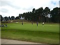
6
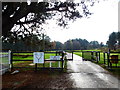
Ridgemount Road enters golf course and becomes a bridleway
Image: © Shazz
Taken: 27 Nov 2014
0.12 miles
7
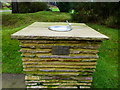
Water for golfers
The plaque reads
Lucifer Golf Society
1993
Sadly only water
See also Image
Image: © Shazz
Taken: 27 Nov 2014
0.18 miles