IMAGES TAKEN NEAR TO
Ridgemount Road, ASCOT, SL5 9RL
Introduction
This page details the photographs taken nearby to Ridgemount Road, SL5 9RL by members of the Geograph project.
The Geograph project started in 2005 with the aim of publishing, organising and preserving representative images for every square kilometre of Great Britain, Ireland and the Isle of Man.

There are currently over 7.5m images from over14,400 individuals and you can help contribute to the project by visiting https://www.geograph.org.uk
Image Map
Images are licensed for reuse under creativecommons.org/licenses/by-sa/2.0
Notes
- Clicking on the map will re-center to the selected point.
- The higher the marker number, the further away the image location is from the centre of the postcode.
Image Listing (39 Images Found)
Images are licensed for reuse under creativecommons.org/licenses/by-sa/2.0
Image
Details
Distance
1
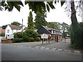
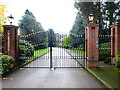
Sunningdale Golf Club - Clubhouse Entrance
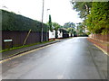
Ridge Mount Road residential road.
Image: © James Emmans
Taken: 16 Jul 2017
0.07 miles
3
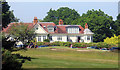
Sunningdale Golf Club
A view of the club house from one of the public footpaths which cross the course.
Image: © Des Blenkinsopp
Taken: 6 Jun 2018
0.11 miles
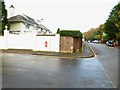
8
Shops at Broomhall
This distinctive row of shops is certainly an improvement over the average parade of shops.
Image: © Ron Strutt
Taken: 1 Sep 2005
0.18 miles
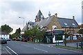
9
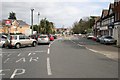
Sunningdale
The level crossing and shopping area on the A30 road.
Image: © Brendan and Ruth McCartney
Taken: 25 Mar 2005
0.18 miles
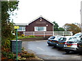
10
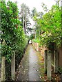
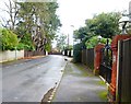
Footpath between Priory Road and Ridgemount Road
Image: © Mike Quinn
Taken: 28 Sep 2012
0.19 miles