IMAGES TAKEN NEAR TO
Brockenhurst Road, ASCOT, SL5 9FW
Introduction
This page details the photographs taken nearby to Brockenhurst Road, SL5 9FW by members of the Geograph project.
The Geograph project started in 2005 with the aim of publishing, organising and preserving representative images for every square kilometre of Great Britain, Ireland and the Isle of Man.

There are currently over 7.5m images from over14,400 individuals and you can help contribute to the project by visiting https://www.geograph.org.uk
Image Map
Images are licensed for reuse under creativecommons.org/licenses/by-sa/2.0
Notes
- Clicking on the map will re-center to the selected point.
- The higher the marker number, the further away the image location is from the centre of the postcode.
Image Listing (18 Images Found)
Images are licensed for reuse under creativecommons.org/licenses/by-sa/2.0
Image
Details
Distance
1
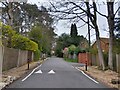
Friary Road
A private road (and public footpath) between Brockenhurst Road (the A330) and Coronation Road.
Image: © Oscar Taylor
Taken: 2 Apr 2023
0.13 miles
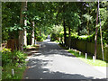
3
Monks Walk
Narrow residential lane in South Ascot
Image: © Richard Croft
Taken: 1 Apr 2008
0.14 miles
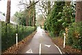
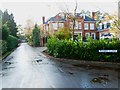
4
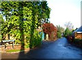
St. Mary's Road
A private residential road but also a public footpath.
Image: © Robin Webster
Taken: 26 Jun 2016
0.14 miles
5
Friary Road
A private road (and public footpath) between Brockenhurst Road (the A330) and Coronation Road.
Image: © Oscar Taylor
Taken: 2 Apr 2023
0.16 miles
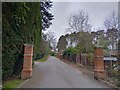
7
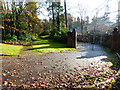
Path passes large gates just off Brockenhurst Road
Image: © Shazz
Taken: 30 Nov 2014
0.18 miles
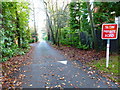
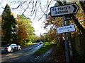
9
Monks Walk looking eastwards from Monks Drive
Image: © Shazz
Taken: 30 Nov 2014
0.18 miles
10
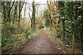
Woodland Walk
Footpath through woodland in Sunninghill
Image: © Richard Croft
Taken: 1 Apr 2008
0.20 miles