IMAGES TAKEN NEAR TO
Charters Road, ASCOT, SL5 9FG
Introduction
This page details the photographs taken nearby to Charters Road, SL5 9FG by members of the Geograph project.
The Geograph project started in 2005 with the aim of publishing, organising and preserving representative images for every square kilometre of Great Britain, Ireland and the Isle of Man.

There are currently over 7.5m images from over14,400 individuals and you can help contribute to the project by visiting https://www.geograph.org.uk
Image Map
Images are licensed for reuse under creativecommons.org/licenses/by-sa/2.0
Notes
- Clicking on the map will re-center to the selected point.
- The higher the marker number, the further away the image location is from the centre of the postcode.
Image Listing (6 Images Found)
Images are licensed for reuse under creativecommons.org/licenses/by-sa/2.0
Image
Details
Distance
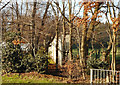
1

Imposing gates off Charters Road
The entrance to Charters, a former grand house now put to other purposes.
Image: © Robin Webster
Taken: 26 Jun 2016
0.21 miles
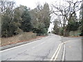
2
All Just For Show 1
These fancy gates don't offer a fat lot of security. Follow the wall along and you could walk round the end. Image
There's only a sports field behind anyway.
Update:- Thanks to Robin Stott for telling me about the "preposterous gates" tag, which is kind of fun, and I think this qualifies.
Image: © Des Blenkinsopp
Taken: 19 Jan 2017
0.21 miles
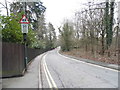
5
All Just For Show 2
This goes with Image and shows how the high wall that flanks a set of imposing gates kind of gives up in some trees after 10 metres or so.
As you see, anyone could walk round the end.
Image: © Des Blenkinsopp
Taken: 19 Jan 2017
0.22 miles
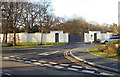
6
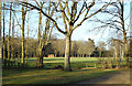
Sports Field, Sunningdale
Attached to a school off to the right.
Image: © Des Blenkinsopp
Taken: 19 Jan 2017
0.25 miles