IMAGES TAKEN NEAR TO
Royal Victoria Gardens, ASCOT, SL5 9ET
Introduction
This page details the photographs taken nearby to Royal Victoria Gardens, SL5 9ET by members of the Geograph project.
The Geograph project started in 2005 with the aim of publishing, organising and preserving representative images for every square kilometre of Great Britain, Ireland and the Isle of Man.

There are currently over 7.5m images from over14,400 individuals and you can help contribute to the project by visiting https://www.geograph.org.uk
Image Map
Images are licensed for reuse under creativecommons.org/licenses/by-sa/2.0
Notes
- Clicking on the map will re-center to the selected point.
- The higher the marker number, the further away the image location is from the centre of the postcode.
Image Listing (30 Images Found)
Images are licensed for reuse under creativecommons.org/licenses/by-sa/2.0
Image
Details
Distance
1
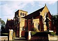
All Souls, South Ascot
Grade 2* listed building erected in 1896.
Image: © Michael FORD
Taken: Unknown
0.07 miles
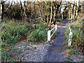
2
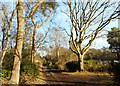
Public Footpath along a Track
This actually looks like a footpath. A lot of the marked public rights of way round here are just along ordinary roads.
But then, a lot of the ordinary roads round here are private.
Whatever. It all seems to work out...
Image: © Des Blenkinsopp
Taken: 19 Jan 2017
0.08 miles
3
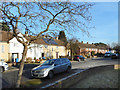
Bouldish Farm Road
Suburban street near Ascot station.
Image: © Des Blenkinsopp
Taken: 19 Jan 2017
0.09 miles
4
Footpath Bridge in the Woods
This square is mostly residential apart from a strip of woodland which is possibly too wet for development.
The footpath through here is on a low causeway, with pools of water on both sides and a sluggish small stream doing a not very good job of drainage.
Image: © Des Blenkinsopp
Taken: 19 Jan 2017
0.11 miles
5
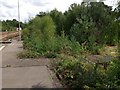
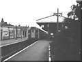
Ascot Station
Secondary succession on the trackbed of the abandoned Platforms 4 and 5, leading to a woodland of birch and Scots pine
Image: © Mick Crawley
Taken: 6 Jun 2004
0.15 miles
6
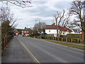
Brockenhurst Road
Brockenhurst road as it approaches South Ascot. The Swinley public house is the first of the brick buildings.
Image: © Alan Hunt
Taken: 5 Apr 2013
0.17 miles
7
Brockenhurst Road, South Ascot
Looking south along Brockenhurst Road with The Swinley public house on the left.
Image: © Alan Hunt
Taken: 5 Apr 2013
0.17 miles
8
Corner of Bouldish Farm Road
Junction with Carroll Crescent.
Image: © Des Blenkinsopp
Taken: 19 Jan 2017
0.17 miles
9
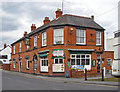
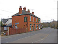
The Swinley public house
The old brick built public house fronting onto Brockenhurst Road in South Ascot.
Image: © Alan Hunt
Taken: 5 Apr 2013
0.18 miles