IMAGES TAKEN NEAR TO
Locks Ride, ASCOT, SL5 8RA
Introduction
This page details the photographs taken nearby to Locks Ride, SL5 8RA by members of the Geograph project.
The Geograph project started in 2005 with the aim of publishing, organising and preserving representative images for every square kilometre of Great Britain, Ireland and the Isle of Man.

There are currently over 7.5m images from over14,400 individuals and you can help contribute to the project by visiting https://www.geograph.org.uk
Image Map
Images are licensed for reuse under creativecommons.org/licenses/by-sa/2.0
Notes
- Clicking on the map will re-center to the selected point.
- The higher the marker number, the further away the image location is from the centre of the postcode.
Image Listing (12 Images Found)
Images are licensed for reuse under creativecommons.org/licenses/by-sa/2.0
Image
Details
Distance
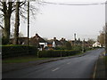
1
Looking from Locks Ride into Chavey Down Road
Image: © Basher Eyre
Taken: 5 Feb 2022
0.07 miles
2
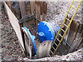
Missing link in Bray Water Pipeline
South East Water constructed a £17m pipeline which was due for completion in December 2008. There still seem to be some holes in it! See also at http://www.geograph.org.uk/photo/1277813
Image: © don cload
Taken: 1 Dec 2009
0.11 miles
4
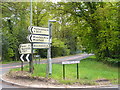
Which Way?
Plenty of road signs to read at the leafy fork of Long Hill Road and Priory Road, Chavey Down.
http://www.berkshirehistory.com/villages/winkfield.html
Image: © Colin Smith
Taken: 9 May 2010
0.16 miles
5
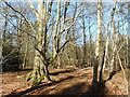
Pump Rough
A bit of woodland amongst the houses.
Image: © Des Blenkinsopp
Taken: 13 Mar 2017
0.18 miles
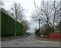
6
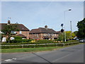
Winkfield Row - Houses on Chavey Down Road
Image: © James Emmans
Taken: 28 May 2017
0.18 miles
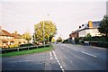
7
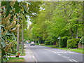
Locks Ride
Leafy and residential road in Winkfield Row. Many of the houses are detached and hidden behind gates and hedges.
http://www.berkshirehistory.com/villages/winkfield.html
Image: © Colin Smith
Taken: 9 May 2010
0.18 miles
8
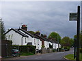
Gorse Row, Chavey Down Road
A row of old cottages strung out along one of the through roads in Winkfield Row.
http://www.berkshirehistory.com/villages/winkfield.html
Image: © Colin Smith
Taken: 9 May 2010
0.19 miles
9
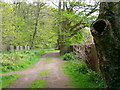
Sandy Lane, Chavey Down
Loose-surfaced leafy byway from Chavey Down to North Ascot. Pump Rough is on the left and houses to the right.
Image: © Colin Smith
Taken: 9 May 2010
0.19 miles