IMAGES TAKEN NEAR TO
The Burlings, ASCOT, SL5 8BY
Introduction
This page details the photographs taken nearby to The Burlings, SL5 8BY by members of the Geograph project.
The Geograph project started in 2005 with the aim of publishing, organising and preserving representative images for every square kilometre of Great Britain, Ireland and the Isle of Man.

There are currently over 7.5m images from over14,400 individuals and you can help contribute to the project by visiting https://www.geograph.org.uk
Image Map
Images are licensed for reuse under creativecommons.org/licenses/by-sa/2.0
Notes
- Clicking on the map will re-center to the selected point.
- The higher the marker number, the further away the image location is from the centre of the postcode.
Image Listing (7 Images Found)
Images are licensed for reuse under creativecommons.org/licenses/by-sa/2.0
Image
Details
Distance
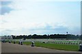
1
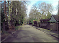
Burleigh Road west of Ascot Heath Racecourse
Image: © Stuart Logan
Taken: 7 Feb 2013
0.10 miles
3
Foot link from Burleigh Road to Sutherland Chase
It requires a close study of maps before attempting a through passage on foot through this area of several self-contained systems of residential dead-end roads - pedestrian links are scarce.
Image: © Robin Webster
Taken: 4 Jun 2016
0.15 miles
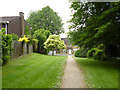
5
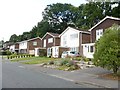
North Ascot - Sutherland Chase
Modern detached houses in residential street.
Image: © James Emmans
Taken: 21 Jul 2017
0.22 miles
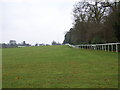
7
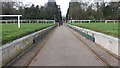
Track gap of Ascot racecourse
The moveable track gap of Ascot racecourse by the Windsor Road gate
Image: © Shaun Ferguson
Taken: 5 Apr 2019
0.25 miles