IMAGES TAKEN NEAR TO
The Chase, ASCOT, SL5 7UJ
Introduction
This page details the photographs taken nearby to The Chase, SL5 7UJ by members of the Geograph project.
The Geograph project started in 2005 with the aim of publishing, organising and preserving representative images for every square kilometre of Great Britain, Ireland and the Isle of Man.

There are currently over 7.5m images from over14,400 individuals and you can help contribute to the project by visiting https://www.geograph.org.uk
Image Map
Images are licensed for reuse under creativecommons.org/licenses/by-sa/2.0
Notes
- Clicking on the map will re-center to the selected point.
- The higher the marker number, the further away the image location is from the centre of the postcode.
Image Listing (7 Images Found)
Images are licensed for reuse under creativecommons.org/licenses/by-sa/2.0
Image
Details
Distance
1
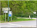
Roundabout Routes, Ascot
Road signs at the double roundabout north-east of Ascot where the Winkfield and Windsor Roads cross.
Image: © Colin Smith
Taken: 9 May 2010
0.11 miles
2
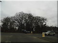
Roundabout on the A332 and A330, North Ascot
Image: © David Howard
Taken: 24 Feb 2013
0.13 miles
3
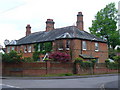
Priors Crossing Road End
Late Victorian red brick cottages on Winkfield Road, north of Ascot.
Image: © Colin Smith
Taken: 9 May 2010
0.13 miles
4
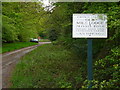
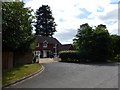
Old Mile Lodge
Leafy private road on Crown Estate land by Ascot Racecourse.
Image: © Colin Smith
Taken: 9 May 2010
0.14 miles
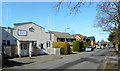
5
Woodend - Manor House Drive
Large detached houses in short Cul-de-sac on the Winkfield Road A330.
Image: © James Emmans
Taken: 16 Jun 2017
0.20 miles
6
Edith Rose Nurseries, New Road
A nursery school in what looks like an old community hall of some kind.
Image: © Des Blenkinsopp
Taken: 13 Mar 2017
0.24 miles
7
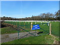
Starting Gate
This is up at the top end of Ascot Race Course where races are presumably started so that they finish in front of the Grandstand at the other end.
Image: © Des Blenkinsopp
Taken: 13 Mar 2017
0.24 miles