IMAGES TAKEN NEAR TO
Silwood Park, Buckhurst Road, ASCOT, SL5 7TG
Introduction
This page details the photographs taken nearby to Silwood Park, Buckhurst Road, SL5 7TG by members of the Geograph project.
The Geograph project started in 2005 with the aim of publishing, organising and preserving representative images for every square kilometre of Great Britain, Ireland and the Isle of Man.

There are currently over 7.5m images from over14,400 individuals and you can help contribute to the project by visiting https://www.geograph.org.uk
Image Map
Images are licensed for reuse under creativecommons.org/licenses/by-sa/2.0
Notes
- Clicking on the map will re-center to the selected point.
- The higher the marker number, the further away the image location is from the centre of the postcode.
Image Listing (50 Images Found)
Images are licensed for reuse under creativecommons.org/licenses/by-sa/2.0
Image
Details
Distance
1
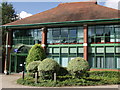
Silwood Science Park Unit A
This building was erected in 1987 on the former parade ground known as North Gravel
Image: © Mick Crawley
Taken: 15 Sep 2010
0.02 miles
2
MScan Building Silwood Park
The building which now serves as Security and Estates Management was re-roofed in 2015
Image: © Mick Crawley
Taken: 6 Apr 2015
0.03 miles
3
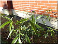
Kennedy Building east side Silwood Park
This plant, Psoralea bituminosa, is a great rarity in Britain. It appeared in the gravel strip between the building and the lawn. We thought it had been killed by the cold in the winter of 2014-15, after the roe deer had eaten all of its seed heads in autumn 2014, but it grew back in 2016 and is still alive in December 2021.
Image: © Mick Crawley
Taken: 10 Nov 2014
0.04 miles
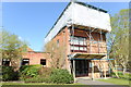
4
East Lodge Silwood Park
For reasons I don't understand, the planners insisted that the new extension (2008) had to be constructed using this peculiar pale-coloured brick.
Image: © Mick Crawley
Taken: 15 Sep 2010
0.05 miles
5
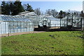
North Gravel Silwood Park
The greenhouse complex was developed between 1947 and 2009 on the former military parade ground to the north of Hamilton Building
Image: © Mick Crawley
Taken: 6 Apr 2015
0.06 miles
6
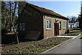
Ladder Store Silwood Park
This wartime building was refurbished with new windows and doors in 2015
Image: © Mick Crawley
Taken: 6 Apr 2015
0.07 miles
7
Greenhouse Header House Silwood Park
The self sown trees on the concrete in the foreground are Alnus cordata
Image: © Mick Crawley
Taken: 19 Oct 2014
0.07 miles
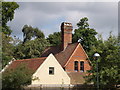
8
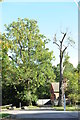
East Lodge Silwood Park
The oak on the right had been slowly dying-back for several years. It was eventually felled in 2015.
Image: © Mick Crawley
Taken: 19 Oct 2014
0.07 miles
9
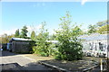
Visitors Block Silwood Park
Formerly known as the Reactor Block it is unlikely to survive the redevelopment
Image: © Mick Crawley
Taken: 19 Oct 2014
0.07 miles
10
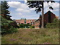
Imperial College London at Silwood Park
These new laboratories, from left to right Kennedy Building, Munro Building and Lees Building, were erected in 1987 to house staff that had moved out following the sale of Ashurst Lodge.
Image: © Mick Crawley
Taken: 1 Jun 2004
0.08 miles