IMAGES TAKEN NEAR TO
Sunninghill Park, Buckhurst Road, ASCOT, SL5 7RQ
Introduction
This page details the photographs taken nearby to Sunninghill Park, Buckhurst Road, SL5 7RQ by members of the Geograph project.
The Geograph project started in 2005 with the aim of publishing, organising and preserving representative images for every square kilometre of Great Britain, Ireland and the Isle of Man.

There are currently over 7.5m images from over14,400 individuals and you can help contribute to the project by visiting https://www.geograph.org.uk
Image Map
Images are licensed for reuse under creativecommons.org/licenses/by-sa/2.0
Notes
- Clicking on the map will re-center to the selected point.
- The higher the marker number, the further away the image location is from the centre of the postcode.
Image Listing (5 Images Found)
Images are licensed for reuse under creativecommons.org/licenses/by-sa/2.0
Image
Details
Distance
2
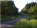
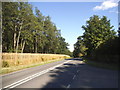
The B383 near Ascot
Passing through Crown Estate woodland. One of the main roads between the Ascot and Windsor areas.
Image: © Andrew Smith
Taken: 5 Jun 2008
0.11 miles
5
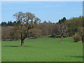
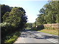
Farmland, Sunninghill Park
The field to the north of Paddock Wood with the B383 marked by the fence and South Forest of Windsor Great Park beyond.
Image: © Alan Hunt
Taken: 23 Apr 2013
0.23 miles