IMAGES TAKEN NEAR TO
Kings Road, ASCOT, SL5 7PS
Introduction
This page details the photographs taken nearby to Kings Road, SL5 7PS by members of the Geograph project.
The Geograph project started in 2005 with the aim of publishing, organising and preserving representative images for every square kilometre of Great Britain, Ireland and the Isle of Man.

There are currently over 7.5m images from over14,400 individuals and you can help contribute to the project by visiting https://www.geograph.org.uk
Image Map
Images are licensed for reuse under creativecommons.org/licenses/by-sa/2.0
Notes
- Clicking on the map will re-center to the selected point.
- The higher the marker number, the further away the image location is from the centre of the postcode.
Image Listing (13 Images Found)
Images are licensed for reuse under creativecommons.org/licenses/by-sa/2.0
Image
Details
Distance
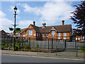
2
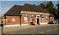
Sunninghill Post Office
c.1930s neo-Georgian post office built to the designs of Office of Works architect David Nicholas Dyke.
Image: © Jim Osley
Taken: 14 Apr 2014
0.16 miles
3
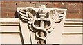
Caduceus, Sunninghill Post Office
The Greek symbol caduceus represents Hermes or Mercury and features on a number of inter-war post office and telephone exchange buildings, e.g.
Image]
Image: © Jim Osley
Taken: 13 Mar 2014
0.16 miles
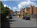
4
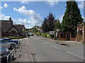
Sunninghill High Street
The High Street running through the centre of Sunninghill
Image: © Alan Hunt
Taken: 15 Jul 2012
0.19 miles
5
Oriental Road from the corner of Upper Village Road
Image: © David Howard
Taken: 3 Feb 2013
0.19 miles
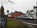
6
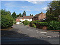
Queen's Road
A view along Queen's Road from its junction with King's Road.
Image: © Alan Hunt
Taken: 15 Jul 2012
0.20 miles
7
Kingswick Close
A short cul-de sac off the A329 The London Road
Image: © Alan Hunt
Taken: 15 Jul 2012
0.20 miles
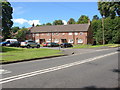
8
St. Michael's C of E Primary School
On Sunninghill High Street.
Image: © Robin Webster
Taken: 29 May 2016
0.20 miles
9
Beechcroft Close
A short cul-de-sac off the Sunninghill Road. All the properties were boarded up at the time that the photograph was taken.
Image: © Alan Hunt
Taken: 15 Jul 2012
0.21 miles
10
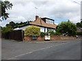
Bungalow on Lower Village Road
On the junction with Quince Close.
Image: © James Emmans
Taken: 21 Jul 2017
0.23 miles