IMAGES TAKEN NEAR TO
Cheapside Road, ASCOT, SL5 7DU
Introduction
This page details the photographs taken nearby to Cheapside Road, SL5 7DU by members of the Geograph project.
The Geograph project started in 2005 with the aim of publishing, organising and preserving representative images for every square kilometre of Great Britain, Ireland and the Isle of Man.

There are currently over 7.5m images from over14,400 individuals and you can help contribute to the project by visiting https://www.geograph.org.uk
Image Map
Images are licensed for reuse under creativecommons.org/licenses/by-sa/2.0
Notes
- Clicking on the map will re-center to the selected point.
- The higher the marker number, the further away the image location is from the centre of the postcode.
Image Listing (17 Images Found)
Images are licensed for reuse under creativecommons.org/licenses/by-sa/2.0
Image
Details
Distance
2
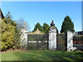
Old Gates to Ascot Race Course
These gates are at the eastern end of the course on a track known as the Old Mile which is now no longer used.
The gates don't appear to have been opened for some time, but are still in reasonable condition.
Image: © Des Blenkinsopp
Taken: 13 Mar 2017
0.04 miles
3
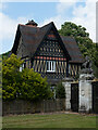
Ascot : Old Golden Gates Lodge
At the former entrance to Ascot race-course. Grade II listed lodge - https://historicengland.org.uk/listing/the-list/list-entry/1119816?section=official-list-entry
Image: © Jim Osley
Taken: 25 May 2023
0.05 miles
4
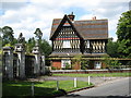
The Golden Gates and lodge
The very grand entrance to the old mile course of Ascot Racecourse.
Image: © don cload
Taken: 3 Aug 2009
0.06 miles
5
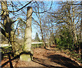
The Winning Post?
I don't know for sure what this is or was. It's beside the footpath which runs along the south side of the old mile race track at Ascot.
It's near the end, so it might have been a marker for the finish of the race, literally The Winning Post.
The race track is no longer used but is kept mown as a sort of long lawn. The path beside it, now part of the Three Castles Walk, is quite secluded behind trees as you see here.
Image: © Des Blenkinsopp
Taken: 13 Mar 2017
0.17 miles
7
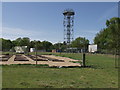
Met Tower Silwood Park
This meteorological tower was built with a grant from the Royal Society to study the use of radar in tracking rain storms. It is now used as a mobile phone mast by all the major telecoms companies.
Image: © Mick Crawley
Taken: 8 Jul 2004
0.19 miles
8
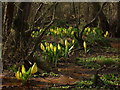
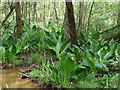
Cascade Marsh
Skunk cabbage (Lysichiton americanus) naturalized in Cascade Marsh, Silwood Lake
Image: © Mick Crawley
Taken: 18 Apr 2004
0.19 miles
9
Cascade Marsh Silwood Park
This fine swampland, flanking the Red Brook (named for the rusty colour of the water caused by the profusion of iron bacteria) is seriously invaded by Skunk Cabbage (Lysichiton americanus) here in leaf in mid-season (the spectacular yellow flowers are over by the end of April)
Image: © Mick Crawley
Taken: 23 May 2008
0.19 miles
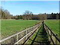
10
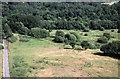
Nursery Field and Rush Meadow Silwood Park
Nursery Field is in the foreground and Rush Meadow in the background (pre-invasion by willows). Picture taken from the top of the Met Tower.
Image: © Mick Crawley
Taken: 15 Jul 1984
0.20 miles