
IMAGES TAKEN NEAR TO
London Road, ASCOT, SL5 7DJ
Introduction
This page details the photographs taken nearby to London Road, SL5 7DJ by members of the Geograph project.
The Geograph project started in 2005 with the aim of publishing, organising and preserving representative images for every square kilometre of Great Britain, Ireland and the Isle of Man.

There are currently over 7.5m images from over14,400 individuals and you can help contribute to the project by visiting https://www.geograph.org.uk
Image Map
Images are licensed for reuse under creativecommons.org/licenses/by-sa/2.0
Notes
- Clicking on the map will re-center to the selected point.
- The higher the marker number, the further away the image location is from the centre of the postcode.
Image Listing (4 Images Found)
Images are licensed for reuse under creativecommons.org/licenses/by-sa/2.0
Image
Details
Distance
1
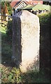
Old Milestone by the A329 in Sunninghill
Carved stone post by the A329, in parish of Sunninghill (Windsor and Maidenhead District), London Road; Agincourt, Wells Hotel, opposite junction with Cheapside Road, on well kept grass verge between road and low hedge around pub garden, on South side of road. Wokingham square, erected by the Windsor Forest turnpike trust in the 19th century.
Inscription reads:-
LONDON
24
MILES
Grade II listed.
List Entry Number: 1109919 https://historicengland.org.uk/listing/the-list/list-entry/1109919
Milestone Society National ID: BE_LRV24
Image: © A Rosevear
Taken: 28 Aug 2002
0.11 miles
3
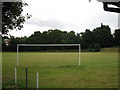
Victory Field, Sunninghill
The larger area of the field including this playing field and other leisure areas comprise Victory Field, a memorial to the men who lost their lives in the First World War.
Image: © don cload
Taken: 2 Sep 2009
0.18 miles
4

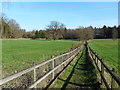
Footpath, Sunninghill
The footpath that runs west from the end of Church Lane towards Cheapside Road.
Image: © Alan Hunt
Taken: 15 Jul 2012
0.19 miles