IMAGES TAKEN NEAR TO
SL5 0XS
Introduction
This page details the photographs taken nearby to SL5 0XS by members of the Geograph project.
The Geograph project started in 2005 with the aim of publishing, organising and preserving representative images for every square kilometre of Great Britain, Ireland and the Isle of Man.

There are currently over 7.5m images from over14,400 individuals and you can help contribute to the project by visiting https://www.geograph.org.uk
Image Map
Images are licensed for reuse under creativecommons.org/licenses/by-sa/2.0
Notes
- Clicking on the map will re-center to the selected point.
- The higher the marker number, the further away the image location is from the centre of the postcode.
Image Listing (37 Images Found)
Images are licensed for reuse under creativecommons.org/licenses/by-sa/2.0
Image
Details
Distance
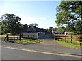
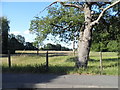
4
Recreation area, Broomhall Lane
The entrance to the recreation area on Broomhall Lane.
Image: © Alan Hunt
Taken: 12 Mar 2012
0.15 miles
5
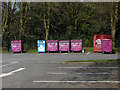
Bottle bank, Sunningdale
The small recycling centre at the entrance to the public car park in Sunningdale complete with some very fetching purple bottle bins.
Image: © Alan Hunt
Taken: 18 Apr 2010
0.18 miles
7
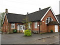
Houses on Church Road, Sunningdale
Holy Trinity primary school is attached on the left.
Image: © David Howard
Taken: 7 Jun 2015
0.19 miles
8
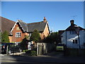
Church Road at the junction of Station Road
Image: © David Howard
Taken: 7 Jun 2015
0.19 miles
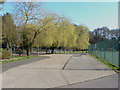
9
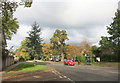
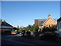
Broomhall Lane, Sunningdale
Aka B383, a B road between Chobham and Cranbourne.
Image: © Des Blenkinsopp
Taken: 7 Nov 2016
0.20 miles
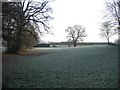
10
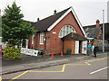
Check point 16 on The Games 100 mile walk
Sunningdale Village Hall
Image: © Ian S
Taken: 3 Jun 2012
0.20 miles