IMAGES TAKEN NEAR TO
Trinity Crescent, ASCOT, SL5 0NQ
Introduction
This page details the photographs taken nearby to Trinity Crescent, SL5 0NQ by members of the Geograph project.
The Geograph project started in 2005 with the aim of publishing, organising and preserving representative images for every square kilometre of Great Britain, Ireland and the Isle of Man.

There are currently over 7.5m images from over14,400 individuals and you can help contribute to the project by visiting https://www.geograph.org.uk
Image Map
Images are licensed for reuse under creativecommons.org/licenses/by-sa/2.0
Notes
- Clicking on the map will re-center to the selected point.
- The higher the marker number, the further away the image location is from the centre of the postcode.
Image Listing (24 Images Found)
Images are licensed for reuse under creativecommons.org/licenses/by-sa/2.0
Image
Details
Distance
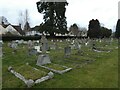
3
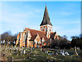
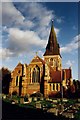
Holy Trinity Church, Sunningdale
View of the church and war memorial from Bedford Lane.The road on the left is Church Road and the road joining from the right is Whitmoor Road.
Image: © Alan Hunt
Taken: 18 Apr 2010
0.03 miles
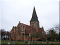
4
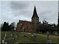
Holy Trinity Church, Sunningdale
A fine early Victorian church built in 1839. Very well cared for, inside and out.
Image: © Des Blenkinsopp
Taken: 19 Jan 2017
0.04 miles
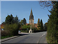
5
Holy Trinity, Sunningdale: early February 2022
Image: © Basher Eyre
Taken: 5 Feb 2022
0.04 miles
6
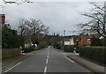
Looking west-southwest along Church Road
Image: © Basher Eyre
Taken: 5 Feb 2022
0.04 miles
7
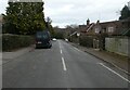
Looking east-northeast along Church Road
Image: © Basher Eyre
Taken: 5 Feb 2022
0.05 miles
8
Holy Trinity, Sunningdale
Grade 2 listed building erected in 1839.
Image: © Michael FORD
Taken: Unknown
0.05 miles
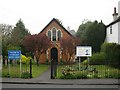
9
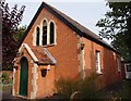
Sunningdale Hope Baptist Chapel
Erected in 1828.
Image: © Michael FORD
Taken: Unknown
0.05 miles