IMAGES TAKEN NEAR TO
London Road, ASCOT, SL5 0LP
Introduction
This page details the photographs taken nearby to London Road, SL5 0LP by members of the Geograph project.
The Geograph project started in 2005 with the aim of publishing, organising and preserving representative images for every square kilometre of Great Britain, Ireland and the Isle of Man.

There are currently over 7.5m images from over14,400 individuals and you can help contribute to the project by visiting https://www.geograph.org.uk
Image Map
Images are licensed for reuse under creativecommons.org/licenses/by-sa/2.0
Notes
- Clicking on the map will re-center to the selected point.
- The higher the marker number, the further away the image location is from the centre of the postcode.
Image Listing (9 Images Found)
Images are licensed for reuse under creativecommons.org/licenses/by-sa/2.0
Image
Details
Distance
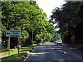
1
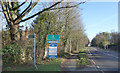
Welcome to Surrey
From Berkshire into Surrey along the A30 on the edge of Sunningdale.
Image: © Des Blenkinsopp
Taken: 29 Jan 2020
0.03 miles
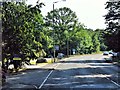
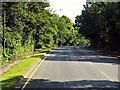
3
Bridleway, Sunningdale
The bridleway running from the A30 towards Coworth Park
Image: © Alan Hunt
Taken: 18 Apr 2010
0.09 miles
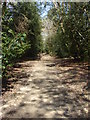
4
Bridleway, Sunningdale
The view along the bridleway running from the A30 towards Cowarth Park
Image: © Alan Hunt
Taken: 18 Apr 2010
0.14 miles
6
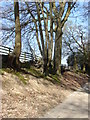
Bridleway, Sunningdale
Beech trees growing alongside the bridleway near Cowarth Park
Image: © Alan Hunt
Taken: 18 Apr 2010
0.18 miles
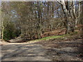
8
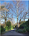
Shrubs Hill Lane
A leafy residential back road which is also a public bridleway.
Image: © Des Blenkinsopp
Taken: 29 Jan 2020
0.23 miles
9
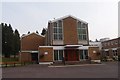
The Sacred Heart Roman Catholic Church, Sunningdale
Erected in 1964.
Image: © Michael FORD
Taken: Unknown
0.24 miles