IMAGES TAKEN NEAR TO
Guards Court, ASCOT, SL5 0ES
Introduction
This page details the photographs taken nearby to Guards Court, SL5 0ES by members of the Geograph project.
The Geograph project started in 2005 with the aim of publishing, organising and preserving representative images for every square kilometre of Great Britain, Ireland and the Isle of Man.

There are currently over 7.5m images from over14,400 individuals and you can help contribute to the project by visiting https://www.geograph.org.uk
Image Map
Images are licensed for reuse under creativecommons.org/licenses/by-sa/2.0
Notes
- Clicking on the map will re-center to the selected point.
- The higher the marker number, the further away the image location is from the centre of the postcode.
Image Listing (61 Images Found)
Images are licensed for reuse under creativecommons.org/licenses/by-sa/2.0
Image
Details
Distance
1
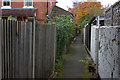
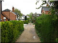
Pathway from Chobham Road to North End Lane
Image: © Robert Eva
Taken: 14 Nov 2017
0.04 miles
2
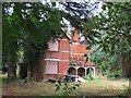
Semi-derelict building, Chobham Road (B383)
Image: © Mike Quinn
Taken: 28 Sep 2012
0.04 miles
3
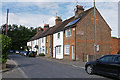
North End Lane, Sunningdale
A terrace in North End Lane, Sunningdale.
Image: © Alan Hunt
Taken: 29 Jul 2015
0.06 miles
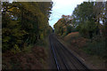
5
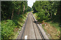
Approaching Sunningdale
Looking northwest in the direction of Sunningdale station from the Chobham Road bridge.
Image: © Alan Hunt
Taken: 29 Jul 2015
0.06 miles
6
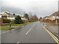
Between the houses
Part of a public footpath (not shown on OS 1:50000 map) behind houses in Broomhall.
Image: © don cload
Taken: 25 Apr 2010
0.06 miles
7
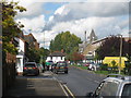
Chobham Road
Towards the centre of Sunningdale
Image: © Oast House Archive
Taken: 6 Oct 2010
0.08 miles
9
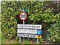
Heather Drive signs
Lots of signs at the entrance to Heather Drive, a private road (cul-de-sac) off Onslow Road.
The top sign denotes the route is a public footpath, though is very faded. The next sign gives the speed limit as 20mph. The next is a road sign of the name "HEATHER DRIVE". Underneath is a sign showing that the road is a dead end and a private road: "PRIVATE ROAD RESIDENT PARKING ONLY". The bottom sign says "CCTV IN USE" with an image of a camera - I wonder if the CCTV is GDPR compliant!
Image: © Oscar Taylor
Taken: 2 Apr 2023
0.10 miles
10
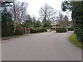
Heather Drive gates
The gates at the entrance and exit of Heather Drive, a cul-de-sac off Onslow Road. The road is the route of a public footpath. The houses have names rather than numbers, are very large and generally in an Ascot style.
Image: © Oscar Taylor
Taken: 2 Apr 2023
0.10 miles