IMAGES TAKEN NEAR TO
Lock Path, WINDSOR, SL4 6QQ
Introduction
This page details the photographs taken nearby to Lock Path, SL4 6QQ by members of the Geograph project.
The Geograph project started in 2005 with the aim of publishing, organising and preserving representative images for every square kilometre of Great Britain, Ireland and the Isle of Man.

There are currently over 7.5m images from over14,400 individuals and you can help contribute to the project by visiting https://www.geograph.org.uk
Image Map
Images are licensed for reuse under creativecommons.org/licenses/by-sa/2.0
Notes
- Clicking on the map will re-center to the selected point.
- The higher the marker number, the further away the image location is from the centre of the postcode.
Image Listing (60 Images Found)
Images are licensed for reuse under creativecommons.org/licenses/by-sa/2.0
Image
Details
Distance
2
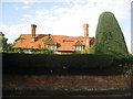
House at Boveney
This displays several attractive Sixteenth century features.
Image: © Jonathan Thacker
Taken: 8 Oct 2010
0.03 miles
3
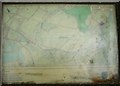
Old Map Showing Dorney Lake Under Construction
This old map was on a noticeboard, by the path to Boveney Church.
Image: © Sean Davis
Taken: 22 May 2009
0.06 miles
4
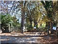
Footpath to Boveney Church
The footpath leads from the Rambler's Car Park to Saint Mary Magdalene's Church on The River Thames.
Image: © Sean Davis
Taken: 22 May 2009
0.07 miles
5
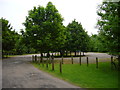
Rambler's Car Park, Boveney
This small car park at Boveney is owned by Eton College. The Rowing Centre at Dorney Lake is just 250m to the southwest. The car park is also used to visit the old Church of St Mary Magdalene, by the River Thames.
Image: © Sean Davis
Taken: 16 May 2008
0.08 miles
6
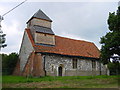
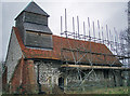
St Mary Magdalene, Boveney
Currently undergoing conservation, the timber framed tower dates from the 16th Century.
Image: © Linda Bailey
Taken: 11 Aug 2005
0.08 miles
7
St Mary Magdalene church, Boveney
This attractive but disused church stands by the Thames Path, and is now maintained by the 'Friends of Friendless Churches'.
Most previous photos of the church have been entered for square Image My own GPS readings suggested that the west (left hand) end was about 12 metres inside SU9377, so probably the 94 eastings grid line bisects the church! But we know that hand-held GPS units have a margin of error, an error which is greater than the quoted accuracy unless the unit is given 5 or 10 minutes to 'settle'. Whatever the true position, I cannot criticise any previous submitter for their choice of square, whichever it was.
Image: © David Purchase
Taken: 29 Apr 2013
0.09 miles
8
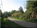
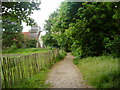
Lock Path, Boveney
Still a road at this point.
Image: © Jonathan Thacker
Taken: 8 Oct 2010
0.09 miles
9
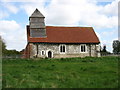
St. Mary Magdalene, Boveney
The earliest parts of this isolated chapel are 12th-13th Century. It probably served a wharf here, and has been a place of worship since before the Norman conquest. The pointing is decorated by flint: a technique known as Galletting.
Image: © Andy Stephenson
Taken: 20 Jan 2008
0.09 miles
10
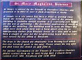
St Mary Magdalene information board
The information board relating to the church of St Mary Magdalene at Boveney. Refer to picture Image for a sunset view of the church.
Image: © Len Williams
Taken: 2 Jan 2015
0.09 miles