IMAGES TAKEN NEAR TO
Tilstone Close, WINDSOR, SL4 6NG
Introduction
This page details the photographs taken nearby to Tilstone Close, SL4 6NG by members of the Geograph project.
The Geograph project started in 2005 with the aim of publishing, organising and preserving representative images for every square kilometre of Great Britain, Ireland and the Isle of Man.

There are currently over 7.5m images from over14,400 individuals and you can help contribute to the project by visiting https://www.geograph.org.uk
Image Map
Images are licensed for reuse under creativecommons.org/licenses/by-sa/2.0
Notes
- Clicking on the map will re-center to the selected point.
- The higher the marker number, the further away the image location is from the centre of the postcode.
Image Listing (17 Images Found)
Images are licensed for reuse under creativecommons.org/licenses/by-sa/2.0
Image
Details
Distance
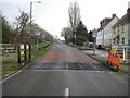
1
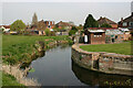
Roundmoor Ditch, Eton Wick
Taken upstream of its confluence with Cress Brook and Boveney Ditch. The houses are in Tilstone Close.
Image: © David Kemp
Taken: 28 Mar 2022
0.04 miles
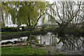
2
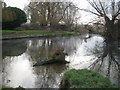
Eton Wick: Confluence of Roundmoor Ditch with Cress Brook
Roundmoor Ditch, on the left, joins with Cress Brook, on the right, here to form Boveney Ditch. Although these watercourses are known as "Ditches" they are large enough in terms of width and depth to be bigger than many so-called rivers.
Eagle-eyed viewers will spot the heron, and the faint wisp of steam coming off the surface of Roundmoor Ditch caused by the air temperature being much lower than the water temperature.
Image: © Nigel Cox
Taken: 9 Jan 2009
0.08 miles
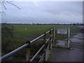
3
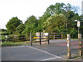
Eton Wick - western approach
This square contains most of Eton Wick. Unlike Eton, this is largely a housing estate of late Victorian and post-war houses. This cattle grid and brook divides Eton Wick from Dorney Common, an open field grazed by cows, and is also the county border between Berkshire and Buckinghamshire.
Image: © Darren Smith
Taken: 7 Jun 2005
0.09 miles
4
Boveney Brook, Dorney Common
The brook is more or less the Buckinghamshire border
Image: © David Howard
Taken: 13 Feb 2012
0.09 miles
5
Confluence of streams, Eton Wick
This is the point at which Roundmoor Ditch (left) and Cress Brook (right) coverge to form Boveney Ditch (centre) before the latter flows into the Thames.
Image: © David Kemp
Taken: 28 Mar 2022
0.09 miles
6
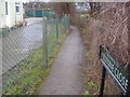
Footpath to Tilstone Close
This runs along the edge of Dorney Common in Eton Wick
Image: © David Howard
Taken: 13 Feb 2012
0.09 miles
7
The entrance to Dorney Common
This marks the border between Berkshire and Buckinghamshire
Image: © David Howard
Taken: 13 Feb 2012
0.10 miles
8
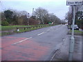
Eton Wick Road
Entering from Dorney and the start of Berkshire
Image: © David Howard
Taken: 13 Feb 2012
0.10 miles
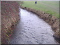
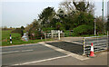
9
Eton Wick: Cattle grid at Tilson Bridge on Eton Wick Road
The cattle grid is there to prevent livestock from Dorney Common from getting into Eton Wick. The road is the B3026 and Tilson Bridge crosses Roundmoor Ditch. The bridge is shown with this name on the 1881 Edition of the Ordnance Survey mapping, long before any of the houses were built.
Image: © Nigel Cox
Taken: 9 Jan 2009
0.11 miles
10
Tilson Bridge, Eton Wick
The bridge carries the B3026 across Roundmoor Ditch whose course can be seen beyond it.
Image: © David Kemp
Taken: 28 Mar 2022
0.12 miles