IMAGES TAKEN NEAR TO
Slough Road, WINDSOR, SL4 6HR
Introduction
This page details the photographs taken nearby to Slough Road, SL4 6HR by members of the Geograph project.
The Geograph project started in 2005 with the aim of publishing, organising and preserving representative images for every square kilometre of Great Britain, Ireland and the Isle of Man.

There are currently over 7.5m images from over14,400 individuals and you can help contribute to the project by visiting https://www.geograph.org.uk
Image Map
Images are licensed for reuse under creativecommons.org/licenses/by-sa/2.0
Notes
- Clicking on the map will re-center to the selected point.
- The higher the marker number, the further away the image location is from the centre of the postcode.
Image Listing (37 Images Found)
Images are licensed for reuse under creativecommons.org/licenses/by-sa/2.0
Image
Details
Distance
1
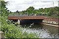
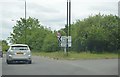
Path beside Slough Road
Crossing the Jubilee River.
Image: © JThomas
Taken: 24 May 2022
0.05 miles
5
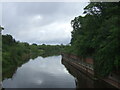
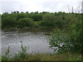
Jubilee River
From the bridge on Slough Road.
Image: © JThomas
Taken: 24 May 2022
0.07 miles
9
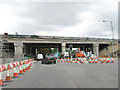
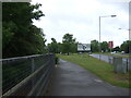
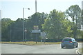
Carriageway widening of the M4
Seen from the Windsor Road - Ragstone Road traffic lights.
Image: © Andy Potter
Taken: 15 Aug 2009
0.09 miles