IMAGES TAKEN NEAR TO
Brocas Street, WINDSOR, SL4 6FB
Introduction
This page details the photographs taken nearby to Brocas Street, SL4 6FB by members of the Geograph project.
The Geograph project started in 2005 with the aim of publishing, organising and preserving representative images for every square kilometre of Great Britain, Ireland and the Isle of Man.

There are currently over 7.5m images from over14,400 individuals and you can help contribute to the project by visiting https://www.geograph.org.uk
Image Map
Images are licensed for reuse under creativecommons.org/licenses/by-sa/2.0
Notes
- Clicking on the map will re-center to the selected point.
- The higher the marker number, the further away the image location is from the centre of the postcode.
Image Listing (991 Images Found)
Images are licensed for reuse under creativecommons.org/licenses/by-sa/2.0
Image
Details
Distance
1
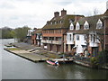
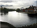
Eton College boathouses from Windsor & Eton Bridge
Image: © Rod Allday
Taken: 6 Apr 2008
0.01 miles
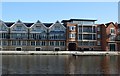
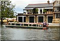
3
Riverside houses at Eton
Seen from over the River Thames at Winsdor.
Image: © Eirian Evans
Taken: 17 Sep 2010
0.02 miles
4
Waterman's Arms, Brocas Street, Eton
Pub in a Grade II listed building with 17th century origins.
Image: © Jaggery
Taken: 24 Oct 2015
0.02 miles
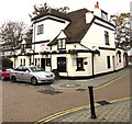
6
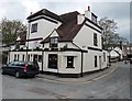
West side of The Watermans Arms, Eton
Viewed across Brocas Street.
The pub's website states that the building dates from 1542. One of its many uses was as a makeshift mortuary in 1665 during the Great Plague. Later it was a watering hole for watermen.
The original Waterman's pub was next to a sawmill in nearby King Stable Street at a time
when the street housed royal carriages and horses for Windsor Castle.
http://www.geograph.org.uk/photo/3474540 to a view of the east side.
Image: © Jaggery
Taken: 27 Apr 2013
0.02 miles
7
East side of The Watermans Arms, Eton
Viewed across Brocas Street.
The pub's website states that the building dates from 1542. One of its many uses was as a makeshift mortuary in 1665 during the Great Plague. Later it was a watering hole for watermen.
The original Waterman's pub was next to a sawmill in nearby King Stable Street at a time
when the street housed royal carriages and horses for Windsor Castle.
http://www.geograph.org.uk/photo/3474544 to a view of the west side.
Image: © Jaggery
Taken: 27 Apr 2013
0.03 miles
8
Wormcatcher on the River Thames
Passing Eton boathouses.
Image: © Gerald England
Taken: 17 Jul 2018
0.03 miles
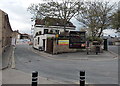
9
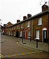
Row of houses, Brocas Street, Eton
Opposite the Waterman's Arms. https://www.geograph.org.uk/photo/5963166
Image: © Jaggery
Taken: 24 Oct 2015
0.03 miles
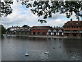
10
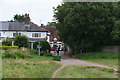
The Thames Path reaches Eton
The pub visible ahead is the Watermans Arms which claims to be the oldest pub in Eton, dating from Tudor times.
Image: © Bill Boaden
Taken: 9 Aug 2012
0.03 miles