IMAGES TAKEN NEAR TO
Eton Wick Road, WINDSOR, SL4 6EZ
Introduction
This page details the photographs taken nearby to Eton Wick Road, SL4 6EZ by members of the Geograph project.
The Geograph project started in 2005 with the aim of publishing, organising and preserving representative images for every square kilometre of Great Britain, Ireland and the Isle of Man.

There are currently over 7.5m images from over14,400 individuals and you can help contribute to the project by visiting https://www.geograph.org.uk
Image Map
Images are licensed for reuse under creativecommons.org/licenses/by-sa/2.0
Notes
- Clicking on the map will re-center to the selected point.
- The higher the marker number, the further away the image location is from the centre of the postcode.
Image Listing (161 Images Found)
Images are licensed for reuse under creativecommons.org/licenses/by-sa/2.0
Image
Details
Distance
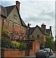
2
Eton Wick Road houses, Eton
Northwest of Eton College. The postbox http://www.geograph.org.uk/photo/4715364 is from the reign of King George V.
Image: © Jaggery
Taken: 24 Oct 2015
0.06 miles
3
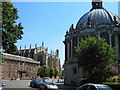
Eton College
This photo shows the Eton College Library on the right (the domed building), the College chapel in the centre, and the original College building on the left. Most of this square is taken up with Eton and Eton Brocas (the fields to the west of Eton by the river).
Image: © Darren Smith
Taken: 10 Jul 2005
0.06 miles
4
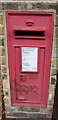
King George V postbox, Eton Wick Road, Eton
Located here. http://www.geograph.org.uk/photo/4715323
The letters GR date the box to the reign of King George V (May 1910-January 1936).
Image: © Jaggery
Taken: 24 Oct 2015
0.07 miles
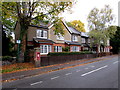
5
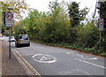
Start of the 20 zone on the approach to Eton College
The 30mph speed limit on the B3026 Eton Wick Road drops to 20.
Image: © Jaggery
Taken: 24 Oct 2015
0.08 miles
6
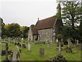
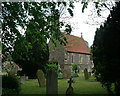
Eton Cemetery Chapel
The cemetery is on the north side of Eton Wick Road.
Image: © Jaggery
Taken: 24 Oct 2015
0.08 miles
7
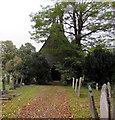
Path to the cemetery chapel, Eton
From Eton Wick Road. http://www.geograph.org.uk/photo/4715379 to a side view of the chapel.
Image: © Jaggery
Taken: 24 Oct 2015
0.08 miles
8
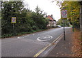
End of the 20mph zone west of Eton College
The 20mph speed limit on the B3026 Eton Wick Road increases to 30.
Image: © Jaggery
Taken: 24 Oct 2015
0.08 miles
9
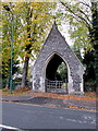
Eton Cemetery lychgate
Viewed across Eton Wick Road. Derived from an old English word for a corpse, a lychgate is the roofed gateway to a churchyard, formerly used to shelter a coffin until the clergyman's arrival for the burial or pre-burial service.
Image: © Jaggery
Taken: 24 Oct 2015
0.08 miles