IMAGES TAKEN NEAR TO
Birch Grove, WINDSOR, SL4 5RT
Introduction
This page details the photographs taken nearby to Birch Grove, SL4 5RT by members of the Geograph project.
The Geograph project started in 2005 with the aim of publishing, organising and preserving representative images for every square kilometre of Great Britain, Ireland and the Isle of Man.

There are currently over 7.5m images from over14,400 individuals and you can help contribute to the project by visiting https://www.geograph.org.uk
Image Map
Images are licensed for reuse under creativecommons.org/licenses/by-sa/2.0
Notes
- Clicking on the map will re-center to the selected point.
- The higher the marker number, the further away the image location is from the centre of the postcode.
Image Listing (16 Images Found)
Images are licensed for reuse under creativecommons.org/licenses/by-sa/2.0
Image
Details
Distance
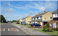
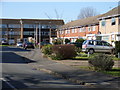
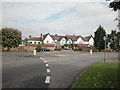
2
Dedworth - Ruddlesway
Modern detached houses.
Image: © James Emmans
Taken: 24 Jun 2017
0.14 miles
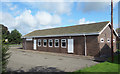
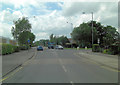
4
Dedworth, Windsor
Looking along Pierson Road from Gallys Road.
Image: © Andrew Smith
Taken: 25 Feb 2006
0.18 miles
6
Van outside laundrette, Dedworth
A Commer van, dating from the early 1970s, parked outside Image which appears stuck in the same era. Surely there cannot be many Commers still running.
Image: © Richard Vince
Taken: 26 Dec 2015
0.24 miles
7
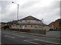
Wash Windsor Laundrette, Dedworth
In a time warp on Dedworth Road.
Image: © Richard Vince
Taken: 26 Dec 2015
0.24 miles
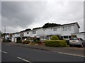
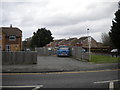
8
Edge of Dedworth
Building converted into apartments at the northern boundary of Dedworth.
Image: © Dennis Turner
Taken: 5 Sep 2005
0.24 miles
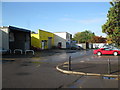
9
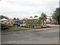
Garden Centre, Dedworth
Near Dedworth.
Image: © Dennis Turner
Taken: 5 Sep 2005
0.24 miles