IMAGES TAKEN NEAR TO
Aston Mead, WINDSOR, SL4 5PP
Introduction
This page details the photographs taken nearby to Aston Mead, SL4 5PP by members of the Geograph project.
The Geograph project started in 2005 with the aim of publishing, organising and preserving representative images for every square kilometre of Great Britain, Ireland and the Isle of Man.

There are currently over 7.5m images from over14,400 individuals and you can help contribute to the project by visiting https://www.geograph.org.uk
Image Map
Images are licensed for reuse under creativecommons.org/licenses/by-sa/2.0
Notes
- Clicking on the map will re-center to the selected point.
- The higher the marker number, the further away the image location is from the centre of the postcode.
Image Listing (8 Images Found)
Images are licensed for reuse under creativecommons.org/licenses/by-sa/2.0
Image
Details
Distance
3
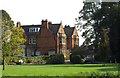
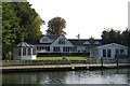
Large house by the River Thames
This house was a retirement home for teachers from Eton College.
Image: © Steve Daniels
Taken: 22 Sep 2014
0.17 miles
4
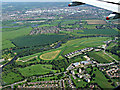
Royal Windsor Race Course from the air
On approach to Heathrow from the west. One of only two figure-of-eight courses in the UK, the other being Fontwell Park.
Image: © Thomas Nugent
Taken: 19 May 2014
0.20 miles
7
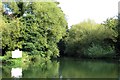
Clewer Mill Stream runs off the River Thames
Clewer Mill Stream flows round the south of Windsor Racecourse.
Image: © Steve Daniels
Taken: 22 Sep 2014
0.23 miles
8
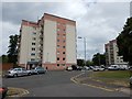
Dedworth - Flats in Sawyer's Close
Windermere and Broadley flats in a development of four blocks.
Image: © James Emmans
Taken: 24 Jun 2017
0.24 miles