IMAGES TAKEN NEAR TO
Tudor Way, WINDSOR, SL4 5LT
Introduction
This page details the photographs taken nearby to Tudor Way, SL4 5LT by members of the Geograph project.
The Geograph project started in 2005 with the aim of publishing, organising and preserving representative images for every square kilometre of Great Britain, Ireland and the Isle of Man.

There are currently over 7.5m images from over14,400 individuals and you can help contribute to the project by visiting https://www.geograph.org.uk
Image Map
Images are licensed for reuse under creativecommons.org/licenses/by-sa/2.0
Notes
- Clicking on the map will re-center to the selected point.
- The higher the marker number, the further away the image location is from the centre of the postcode.
Image Listing (8 Images Found)
Images are licensed for reuse under creativecommons.org/licenses/by-sa/2.0
Image
Details
Distance
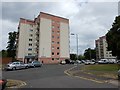
2

Sawyer's Close, Windsor
There are four similar towerblocks. This is the most southerly.
Image: © Andrew Smith
Taken: 25 Feb 2006
0.13 miles
4
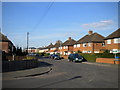
Hanover Way, Dedworth
The houses here are typical of this part of Dedworth. Far newer flats can be glimpsed in the distance, at the point where Hanover Way turns east to meet Vale Road. Hanover Way continues south to the photographer's right; however, traffic approaching along Dedworth Drive (foreground) has right of way.
Image: © Richard Vince
Taken: 6 Apr 2013
0.19 miles
5
Dedworth - Flats in Sawyer's Close
Windermere and Broadley flats in a development of four blocks.
Image: © James Emmans
Taken: 24 Jun 2017
0.21 miles
7
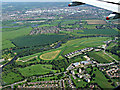
Royal Windsor Race Course from the air
On approach to Heathrow from the west. One of only two figure-of-eight courses in the UK, the other being Fontwell Park.
Image: © Thomas Nugent
Taken: 19 May 2014
0.23 miles
8
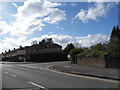
Dedworth Road at the junction of Stuart Way
Image: © David Howard
Taken: 3 May 2015
0.23 miles