IMAGES TAKEN NEAR TO
Clewer Park, WINDSOR, SL4 5HB
Introduction
This page details the photographs taken nearby to Clewer Park, SL4 5HB by members of the Geograph project.
The Geograph project started in 2005 with the aim of publishing, organising and preserving representative images for every square kilometre of Great Britain, Ireland and the Isle of Man.

There are currently over 7.5m images from over14,400 individuals and you can help contribute to the project by visiting https://www.geograph.org.uk
Image Map
Images are licensed for reuse under creativecommons.org/licenses/by-sa/2.0
Notes
- Clicking on the map will re-center to the selected point.
- The higher the marker number, the further away the image location is from the centre of the postcode.
Image Listing (105 Images Found)
Images are licensed for reuse under creativecommons.org/licenses/by-sa/2.0
Image
Details
Distance
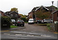
1
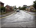
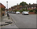
Clewer Park, Clewer Village, Windsor
Viewed from Mill Lane. Signs on each sign of the Clewer Park roadway show
Resident permit holders parking only past this point 9am-6pm.
Image: © Jaggery
Taken: 24 Oct 2015
0.04 miles
3
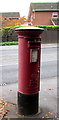
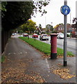
Queen Elizabeth II pillarbox, Maidenhead Road, Windsor
Located here. http://www.geograph.org.uk/photo/4714032
Image: © Jaggery
Taken: 24 Oct 2015
0.07 miles
4
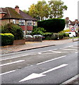
40mph speed limit, Maidenhead Road, Windsor
In many locations in the UK, the speed limit is 30mph or lower where houses are nearby.
Here, it's 40mph on the A308 Maidenhead Road in Windsor.
Image: © Jaggery
Taken: 24 Oct 2015
0.07 miles
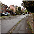
5
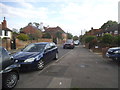
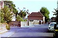
Mill Lane, Clewer Village, Windsor
From the corner of Clewer Court Road looking along Mill Lane towards Maidenhead Road.
Image: © Jaggery
Taken: 24 Oct 2015
0.07 miles
6
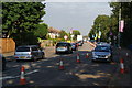
Slow traffic on Maidenhead Road
I don't know whether the cones were related to roadworks (which I didn't see) or the nearby Olympic event.
Image: © Bill Boaden
Taken: 9 Aug 2012
0.07 miles
7
Former Windsor Youth Hostel, Mill Lane, Clewer, 1983
The building in the centre of this view formed part of the YHA's Windsor Youth Hostel, which closed in 2002. In 1983 it was classed as "Standard" grade.
Image: © Nigel Thompson
Taken: 13 Jul 1983
0.08 miles
8
Footpath and cycleway sign, Maidenhead Road, Windsor
On the north side of the A308 Maidenhead Road.
Image: © Jaggery
Taken: 24 Oct 2015
0.08 miles
9
Wells Close, Windsor
Cul-de-sac on the south side of the A308 Maidenhead Road.
Image: © Jaggery
Taken: 24 Oct 2015
0.08 miles
10
West along Clewer Court Road, Clewer Village, Windsor
Towards Mill Lane.
Image: © Jaggery
Taken: 24 Oct 2015
0.08 miles