IMAGES TAKEN NEAR TO
Kenneally Road, WINDSOR, SL4 4XP
Introduction
This page details the photographs taken nearby to Kenneally Road, SL4 4XP by members of the Geograph project.
The Geograph project started in 2005 with the aim of publishing, organising and preserving representative images for every square kilometre of Great Britain, Ireland and the Isle of Man.

There are currently over 7.5m images from over14,400 individuals and you can help contribute to the project by visiting https://www.geograph.org.uk
Image Map
Images are licensed for reuse under creativecommons.org/licenses/by-sa/2.0
Notes
- Clicking on the map will re-center to the selected point.
- The higher the marker number, the further away the image location is from the centre of the postcode.
Image Listing (4 Images Found)
Images are licensed for reuse under creativecommons.org/licenses/by-sa/2.0
Image
Details
Distance
1
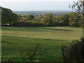
Field near Dedworth
A panoramic view from the footpath to St Leonard's Hill looking across the Thames flood plain towards the Chiltern Hills.
Image: © Alan Hunt
Taken: 23 Oct 2011
0.18 miles
3
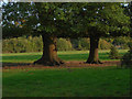
Oak Trees
Oaks growing in the field to the east of Tarbay Lane
Image: © Alan Hunt
Taken: 23 Oct 2011
0.23 miles
4
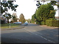
Tinkers Lane
Tinkers Lane in Dedworth with the junction of Basford Way on the left.
Image: © Alan Hunt
Taken: 23 Oct 2011
0.23 miles