IMAGES TAKEN NEAR TO
Chestnut Drive, WINDSOR, SL4 4UT
Introduction
This page details the photographs taken nearby to Chestnut Drive, SL4 4UT by members of the Geograph project.
The Geograph project started in 2005 with the aim of publishing, organising and preserving representative images for every square kilometre of Great Britain, Ireland and the Isle of Man.

There are currently over 7.5m images from over14,400 individuals and you can help contribute to the project by visiting https://www.geograph.org.uk
Image Map
Images are licensed for reuse under creativecommons.org/licenses/by-sa/2.0
Notes
- Clicking on the map will re-center to the selected point.
- The higher the marker number, the further away the image location is from the centre of the postcode.
Image Listing (6 Images Found)
Images are licensed for reuse under creativecommons.org/licenses/by-sa/2.0
Image
Details
Distance
2
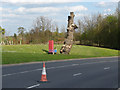
Managed landscape, Legoland
The managed areas along the access road to the Legoland car parks.
Image: © Alan Hunt
Taken: 14 Apr 2014
0.17 miles
3
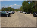
Windsor park and ride
The Windsor park and ride car park off the access road to Legoland.
Image: © Alan Hunt
Taken: 14 Apr 2014
0.20 miles
4
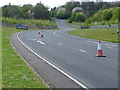
Legoland access road
The access road from the B3022 to the Legoland car parks.
Image: © Alan Hunt
Taken: 14 Apr 2014
0.21 miles
5
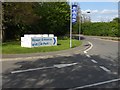
Legoland sign
The sign on the access road to the Legoland car parks.
Image: © Alan Hunt
Taken: 14 Apr 2014
0.22 miles
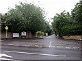
6
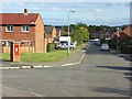
Clewer Green
Looking down Perrycroft from the junction with Rydings.
Image: © Andrew Smith
Taken: 23 Sep 2007
0.24 miles