IMAGES TAKEN NEAR TO
Drift Road, WINDSOR, SL4 4RL
Introduction
This page details the photographs taken nearby to Drift Road, SL4 4RL by members of the Geograph project.
The Geograph project started in 2005 with the aim of publishing, organising and preserving representative images for every square kilometre of Great Britain, Ireland and the Isle of Man.

There are currently over 7.5m images from over14,400 individuals and you can help contribute to the project by visiting https://www.geograph.org.uk
Image Map
Images are licensed for reuse under creativecommons.org/licenses/by-sa/2.0
Notes
- Clicking on the map will re-center to the selected point.
- The higher the marker number, the further away the image location is from the centre of the postcode.
Image Listing (3 Images Found)
Images are licensed for reuse under creativecommons.org/licenses/by-sa/2.0
Image
Details
Distance
1
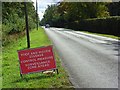
Winkfield Plain
The straight section of road at Winkfield Place as it enters the surveillance zone set up following the foot-and-mouth outbreak at Egham.
Image: © Andrew Smith
Taken: 23 Sep 2007
0.20 miles
2
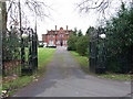
Cranbourne Hall
Prior to its demolition - see Image
Image: © Andrew Smith
Taken: 22 Jan 2006
0.22 miles
3
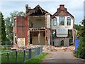
Cranbourne Hall
Demolition prior to its replacement with apartments and houses.
Image: © Andrew Smith
Taken: 23 Sep 2007
0.22 miles