IMAGES TAKEN NEAR TO
Drift Road, WINDSOR, SL4 4QL
Introduction
This page details the photographs taken nearby to Drift Road, SL4 4QL by members of the Geograph project.
The Geograph project started in 2005 with the aim of publishing, organising and preserving representative images for every square kilometre of Great Britain, Ireland and the Isle of Man.

There are currently over 7.5m images from over14,400 individuals and you can help contribute to the project by visiting https://www.geograph.org.uk
Image Map
Images are licensed for reuse under creativecommons.org/licenses/by-sa/2.0
Notes
- Clicking on the map will re-center to the selected point.
- The higher the marker number, the further away the image location is from the centre of the postcode.
Image Listing (8 Images Found)
Images are licensed for reuse under creativecommons.org/licenses/by-sa/2.0
Image
Details
Distance
1
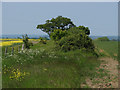
Footpath, Wakers Farm
The footpath that runs from Drift Road to Forest Green Road.
Image: © Alan Hunt
Taken: 6 Jun 2013
0.15 miles
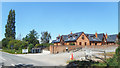
2
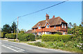
Houses near Haws Hill Farm
Farm cottages for Haws Hill Farm at a guess.
Image: © Des Blenkinsopp
Taken: 7 Aug 2020
0.17 miles
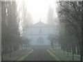
3
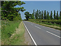
Drift Road
Looking east along Drift Road with the lombardy poplars along the dive of Foliejon Park
Image: © Alan Hunt
Taken: 6 Jun 2013
0.18 miles
4
Navigating northwards up the Bashire (41)
The nearest I can get: my first no-show going up: the gates of Foliejon Park are the nearest I can get to SU9074- Navigating northwards up the Bashire (40)
Image: © Basher Eyre
Taken: 3 Jul 2024
0.21 miles
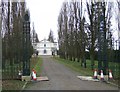
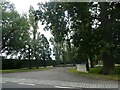
6
The entrance to Foliejon Park
Taken from the Drift Road. The avenue of poplars continues southwards for about a kilometre.
Image: © Andrew Smith
Taken: 22 Jan 2006
0.25 miles
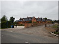
8
Haws Hill Court
New housing at Haws Hill Farm. The farm itself is behind, up the track in the foreground.
Image: © Des Blenkinsopp
Taken: 7 Aug 2020
0.25 miles