IMAGES TAKEN NEAR TO
Oakley Green Road, WINDSOR, SL4 4QF
Introduction
This page details the photographs taken nearby to Oakley Green Road, SL4 4QF by members of the Geograph project.
The Geograph project started in 2005 with the aim of publishing, organising and preserving representative images for every square kilometre of Great Britain, Ireland and the Isle of Man.

There are currently over 7.5m images from over14,400 individuals and you can help contribute to the project by visiting https://www.geograph.org.uk
Image Map
Images are licensed for reuse under creativecommons.org/licenses/by-sa/2.0
Notes
- Clicking on the map will re-center to the selected point.
- The higher the marker number, the further away the image location is from the centre of the postcode.
Image Listing (7 Images Found)
Images are licensed for reuse under creativecommons.org/licenses/by-sa/2.0
Image
Details
Distance
2
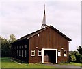
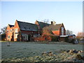
Former Braywood Church
Replaced All Saints, Braywood for the Church of England but is now rented by Braywood First School adjacent for use as the school hall.
Image: © Michael FORD
Taken: Unknown
0.06 miles
3
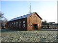
Church building at Braywood
I think this is more of a church hall than a church, but marked on the OS map as a place of worship.
Image: © Andrew Smith
Taken: 22 Jan 2006
0.07 miles
4
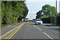
B3024 Oakley Green Road
Towards Windsor.
Image: © Robin Webster
Taken: 26 Sep 2021
0.09 miles
6
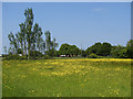
Buttercup field
A field to the south of Oakley Green road from the footpath to Braywood House. The tall trees mark the position of a small pond.
Image: © Alan Hunt
Taken: 6 Jun 2013
0.23 miles
7
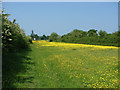
The long field
A long thin buttercup field on the footpath from Oakley Green Road to Braywood House.
Image: © Alan Hunt
Taken: 6 Jun 2013
0.23 miles