IMAGES TAKEN NEAR TO
Priest Hill, WINDSOR, SL4 2JB
Introduction
This page details the photographs taken nearby to Priest Hill, SL4 2JB by members of the Geograph project.
The Geograph project started in 2005 with the aim of publishing, organising and preserving representative images for every square kilometre of Great Britain, Ireland and the Isle of Man.

There are currently over 7.5m images from over14,400 individuals and you can help contribute to the project by visiting https://www.geograph.org.uk
Image Map
Images are licensed for reuse under creativecommons.org/licenses/by-sa/2.0
Notes
- Clicking on the map will re-center to the selected point.
- The higher the marker number, the further away the image location is from the centre of the postcode.
Image Listing (17 Images Found)
Images are licensed for reuse under creativecommons.org/licenses/by-sa/2.0
Image
Details
Distance
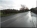
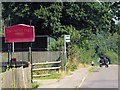
2
Priest Hill by Beaumont Farm
The farm was mainly stables with plenty of activity going on.
Image: © David Howard
Taken: 20 Dec 2015
0.03 miles
4
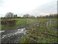
Muddy field by Priest Hill
This is used for the horses from Beaumont Farm opposite
Image: © David Howard
Taken: 20 Dec 2015
0.04 miles
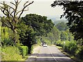
6
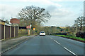
A328 Priest Hill by Beaumont Farm
Dropping down into the Thames valley.
Image: © Robin Webster
Taken: 8 Dec 2019
0.07 miles
8
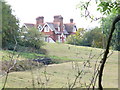
South Lodge Farm
Large house with Tudor-style chimneys on the fringes of Windsor Great Park at Runnymede.
Image: © Colin Smith
Taken: 20 Sep 2009
0.17 miles
9
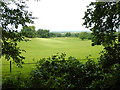
View from Coopers Hill
Beaumont Farm in the distance.
Image: © James Emmans
Taken: 7 Jun 2017
0.17 miles
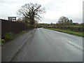
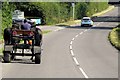
10
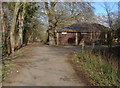
Road to Priest Hill Farm
The road that leads from Priest Hill to the farm with the entrance to the National Trust property of Coopers Hill Slopes and the Kennedy Memorial to the left of the building.
Image: © Alan Hunt
Taken: 26 Feb 2012
0.20 miles