IMAGES TAKEN NEAR TO
Mill Lane, SLOUGH, SL3 9PJ
Introduction
This page details the photographs taken nearby to Mill Lane, SL3 9PJ by members of the Geograph project.
The Geograph project started in 2005 with the aim of publishing, organising and preserving representative images for every square kilometre of Great Britain, Ireland and the Isle of Man.

There are currently over 7.5m images from over14,400 individuals and you can help contribute to the project by visiting https://www.geograph.org.uk
Image Map
Images are licensed for reuse under creativecommons.org/licenses/by-sa/2.0
Notes
- Clicking on the map will re-center to the selected point.
- The higher the marker number, the further away the image location is from the centre of the postcode.
Image Listing (38 Images Found)
Images are licensed for reuse under creativecommons.org/licenses/by-sa/2.0
Image
Details
Distance
1
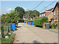
Mill Lane, Horton
A residential cul-de-sac off the Stanwell Road to the east of Horton.
Image: © Alan Hunt
Taken: 5 Sep 2013
0.02 miles
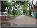
4
Berkyn Manor Farm
The gatehouse of Berkyn Manor Farm on Stanwell Road. The poet John Milton lived at the manor between 1632 and 1638.
Image: © Eirian Evans
Taken: 2 Jul 2013
0.09 miles
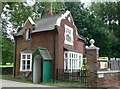
5
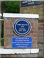
John Milton Lived Here!
Blue plaque near the gateway to Berkyn Manor Farm.
Image: © Eirian Evans
Taken: 2 Jul 2013
0.09 miles
6
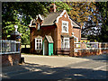
Berkyn Manor Farm
The gatehouse of Berkyn Manor Farm on Stanwell Road. The farm replaced an ancient manor house that was lived in by John Milton between the years of 1632 and 1638 after he had completed his MA at Cambridge until he left for Italy.
Image: © Alan Hunt
Taken: 5 Sep 2013
0.09 miles
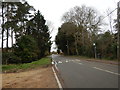
7
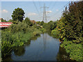
Colne Brook
The Colne Brook looking north from the Stanwell Road bridge to the east of Horton Village.
Image: © Alan Hunt
Taken: 5 Sep 2013
0.09 miles
8
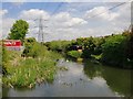
Colne Brook: view upstream
The wider area is a patchwork of land-uses: reservoirs and other industrial sites, old gravel pits (often surrounded by woodland or scrub), with residential areas focused around old village centres. The whole is neither rural nor suburban, though 'urban fringe' would be a fair description. Heathrow and the M25 are major presences.
It isn't easy to imagine the landscape as it must have been in Napoleonic times - before the arrival of large-scale gravel extraction and (later) the huge reservoirs.
The fenced-off area on the left is - I believe - occupied by a road-haulage firm.
Image: © Stefan Czapski
Taken: 6 May 2013
0.09 miles
9
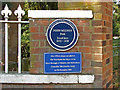
Blue plaque, Berkyn Manor Farm
The blue plaque on the gatepost of Berkyn Manor Farm commemorating one of Horton's most distinguished former resedents.
Image: © Alan Hunt
Taken: 5 Sep 2013
0.10 miles
10
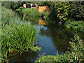
Colne Brook
The Colne Brook from the Stanwell Road bridge. The Colne Brook and the Colne River are separate water courses both feeding into the Thames near Staines.
Image: © Alan Hunt
Taken: 5 Sep 2013
0.10 miles