IMAGES TAKEN NEAR TO
Manor House Lane, SLOUGH, SL3 9EB
Introduction
This page details the photographs taken nearby to Manor House Lane, SL3 9EB by members of the Geograph project.
The Geograph project started in 2005 with the aim of publishing, organising and preserving representative images for every square kilometre of Great Britain, Ireland and the Isle of Man.

There are currently over 7.5m images from over14,400 individuals and you can help contribute to the project by visiting https://www.geograph.org.uk
Image Map
Images are licensed for reuse under creativecommons.org/licenses/by-sa/2.0
Notes
- Clicking on the map will re-center to the selected point.
- The higher the marker number, the further away the image location is from the centre of the postcode.
Image Listing (221 Images Found)
Images are licensed for reuse under creativecommons.org/licenses/by-sa/2.0
Image
Details
Distance
1
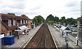
![Datchet railway station [1]](https://s0.geograph.org.uk/geophotos/07/04/21/7042164_b137492a_120x120.jpg)
Datchet railway station [1]
Looking along the rails towards Windsor. The High Street level crossing is just beyond the footbridge.
Datchet station was opened in 1848 and is a stop on the London Waterloo to Staines and Windsor & Eton Line.
Image: © Michael Dibb
Taken: 19 Aug 2021
0.01 miles
2
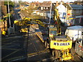
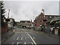
Datchet: High Street level crossing
Sunday morning maintenance work on the level crossing is in progress by Balfour Beatty here. The cranes are hired in from Hydrex http://www.hydrex.co.uk/pages/aboutus.htm and have both road wheels with tyres and steel rail wheels with flanges.
From a Geograph point of view the Ordnance Survey large scale maps show the 177000 Northing grid line just clipping across the top of the far corner of the level crossing here.
Image: © Nigel Cox
Taken: 7 Dec 2008
0.02 miles
3
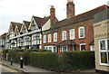
Listed buildings, Datchet
Very similar to Image, but an opportunity to identify the listed buildings. The brick pair to the right ("late C18 red brick front on C17 three bay timber frame") are Manor Cottage and Manor Green Cottage https://www.historicengland.org.uk/listing/the-list/list-entry/1117633 . To the left is The Manor House, "late C16/early C17 four bay timber framed house ... Front rendered and colourwashed with applied timbers in "Jacobean" style, done well. Three storeys with oversailing second floor. Three gables and one larger to left hand with attic" https://www.historicengland.org.uk/listing/the-list/list-entry/1313081 .
Image: © Derek Harper
Taken: 1 Apr 2018
0.02 miles
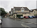
6
Railway station, Datchet
The railway station at Datchet, served by trains on the Windsor & Eton Riverside to London Waterloo line. Viewed from the station footbridge, looking towards London.
Image: © Chris Wood
Taken: 17 Jun 2007
0.02 miles
7
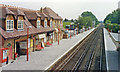
Datchet station
View SE, towards Staines and Waterloo: ex-LSWR Waterloo - Richmond - Staines - Windsor & Eton line. Note the boutiques on the Up platform of the recently modernised station.
Image: © Ben Brooksbank
Taken: 10 Aug 1990
0.02 miles
9
![Datchet buildings [9]](https://s0.geograph.org.uk/geophotos/07/04/21/7042160_f2e57f3d_120x120.jpg)
Datchet buildings [9]
Manor Cottage and Manor Green Cottage, The Green, were built as one house in the 16th or 17th century. Timber framed and refronted in brick in the late 18th century, all under an old tile roof. Listed, grade II, with details at: https://historicengland.org.uk/listing/the-list/list-entry/1117633
Datchet is a village on the north bank of the River Thames in the Royal Borough of Windsor and Maidenhead in Berkshire, about 1¼ miles east of Windsor. There is evidence of continuous occupation since the end of the last ice age. The village developed because of the ferry service which connected it to the main London Road across the River Thames. Now a pleasant commuter village with Waterloo station only 54 minutes away.
Image: © Michael Dibb
Taken: 19 Aug 2021
0.03 miles
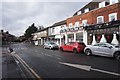
10
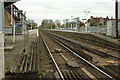
Datchet Station
Seen from the level crossing on the B470.
Image: © Derek Harper
Taken: 1 Apr 2018
0.03 miles