IMAGES TAKEN NEAR TO
High Street, SLOUGH, SL3 9EA
Introduction
This page details the photographs taken nearby to High Street, SL3 9EA by members of the Geograph project.
The Geograph project started in 2005 with the aim of publishing, organising and preserving representative images for every square kilometre of Great Britain, Ireland and the Isle of Man.

There are currently over 7.5m images from over14,400 individuals and you can help contribute to the project by visiting https://www.geograph.org.uk
Image Map
Images are licensed for reuse under creativecommons.org/licenses/by-sa/2.0
Notes
- Clicking on the map will re-center to the selected point.
- The higher the marker number, the further away the image location is from the centre of the postcode.
Image Listing (220 Images Found)
Images are licensed for reuse under creativecommons.org/licenses/by-sa/2.0
Image
Details
Distance
1
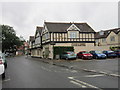
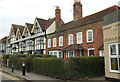
![Datchet buildings [11]](https://s3.geograph.org.uk/geophotos/07/04/21/7042163_77a203e7_120x120.jpg)
Datchet buildings [11]
Numbers 6 and 8 High Street were built in the late 18th century, with many later alterations. Constructed of red brick under a tiled mansard roof. The shopfronts are early 20th century. Some original internal features remain. Listed, grade II, with details at: https://historicengland.org.uk/listing/the-list/list-entry/1117634
Datchet is a village on the north bank of the River Thames in the Royal Borough of Windsor and Maidenhead in Berkshire, about 1¼ miles east of Windsor. There is evidence of continuous occupation since the end of the last ice age. The village developed because of the ferry service which connected it to the main London Road across the River Thames. Now a pleasant commuter village with Waterloo station only 54 minutes away.
Image: © Michael Dibb
Taken: 19 Aug 2021
0.00 miles
4
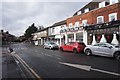
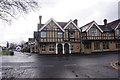
Buildings on The Green, Datchet
A slightly wider view than Image, with Datchet Food & Wine occupying the ground floor of the timbered building at the corner of the High Street. On the immediate left is the Manor Hotel overhanging the pavement; mind your head.
Image: © Derek Harper
Taken: 1 Apr 2018
0.02 miles
5
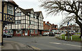
Listed buildings, Datchet
Very similar to Image, but an opportunity to identify the listed buildings. The brick pair to the right ("late C18 red brick front on C17 three bay timber frame") are Manor Cottage and Manor Green Cottage https://www.historicengland.org.uk/listing/the-list/list-entry/1117633 . To the left is The Manor House, "late C16/early C17 four bay timber framed house ... Front rendered and colourwashed with applied timbers in "Jacobean" style, done well. Three storeys with oversailing second floor. Three gables and one larger to left hand with attic" https://www.historicengland.org.uk/listing/the-list/list-entry/1313081 .
Image: © Derek Harper
Taken: 1 Apr 2018
0.02 miles
7
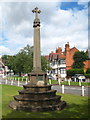
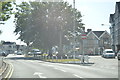
Monument on The Green in Datchet
Erected in commemoration of Queen Victoria's Diamond Jubilee 1837-1897. With commendable economy the parishioners have applied further plaques to the base to commemorate Queen Elizabeth II's Silver 1952-1977 and Golden 1952-2002 Jubilees.
Image: © Rod Allday
Taken: 21 Jun 2011
0.02 miles
9
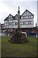
![Datchet features [2]](https://s3.geograph.org.uk/geophotos/07/04/13/7041371_1ec080a8_120x120.jpg)
Datchet features [2]
This cross was erected in 1897 to commemorate the Diamond Jubilee of Queen Victoria. The cross was the gift of Mrs Crake of The Lawn in Horton Road.
Datchet is a village on the north bank of the River Thames in the Royal Borough of Windsor and Maidenhead in Berkshire, about 1¼ miles east of Windsor. There is evidence of continuous occupation since the end of the last ice age. The village developed because of the ferry service which connected it to the main London Road across the River Thames. Now a pleasant commuter village with Waterloo station only 54 minutes away.
Image: © Michael Dibb
Taken: 19 Aug 2021
0.02 miles