IMAGES TAKEN NEAR TO
Ditton Park Road, SLOUGH, SL3 7JB
Introduction
This page details the photographs taken nearby to Ditton Park Road, SL3 7JB by members of the Geograph project.
The Geograph project started in 2005 with the aim of publishing, organising and preserving representative images for every square kilometre of Great Britain, Ireland and the Isle of Man.

There are currently over 7.5m images from over14,400 individuals and you can help contribute to the project by visiting https://www.geograph.org.uk
Image Map
Images are licensed for reuse under creativecommons.org/licenses/by-sa/2.0
Notes
- Clicking on the map will re-center to the selected point.
- The higher the marker number, the further away the image location is from the centre of the postcode.
Image Listing (33 Images Found)
Images are licensed for reuse under creativecommons.org/licenses/by-sa/2.0
Image
Details
Distance
1
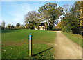
Cycle Route 61 in Ditton Park
National Cycle Route 61 goes through Ditton Park on its route between Maidenhead and Rye House near Ware in Hertfordshire. The old estate chapel is behind the trees.
Image: © Des Blenkinsopp
Taken: 30 Oct 2017
0.08 miles
2
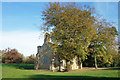
Chapel in Ditton Park
A short distance from the manor house is the estate chapel on an open site beside what is now a national cycle route.
The manor site is medieval, but the present house and chapel are early 19th century.
Image: © Des Blenkinsopp
Taken: 30 Oct 2017
0.10 miles
3
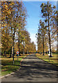
Driveway to Ditton Park Manor
The original entrance to the estate, and still the access for the Manor House and adjacent buildings.
The more recent units on the nearby business park are accessed from a different entrance.
Image: © Des Blenkinsopp
Taken: 30 Oct 2017
0.12 miles
5
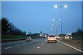
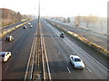
Windsor and Maidenhead : M4 Motorway
The M4 Motorway between Junction 6 (Tuns Lane) and Junction 5 (Langley Roundabout).
Image: © Lewis Clarke
Taken: 23 Mar 2018
0.13 miles
6
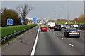
M4 at Langley
Langley, also known as Langley Marish, is a large village 2 miles to the east of central Slough. Since the end of World War II, it has become contiguous with Slough and could now be regarded as a suburb.
Image: © David Dixon
Taken: 8 Apr 2015
0.13 miles
7
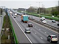
Eastbound M4 from the Footbridge at Langley
Looking towards Junction 5 of the M4 from the footbridge at Langley.
Image: © David Dixon
Taken: 8 Apr 2015
0.16 miles
8
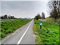
Cyclepath next to the M4 Motorway and the Queen Mother Reservoir
Image: © David Dixon
Taken: 8 Apr 2015
0.16 miles
9
M4 Motorway near Datchet
Looking straight down the central reservation towards Junction 5 from Image, the B470 Major's Farm Road is on the right and Riding Court Road is on the left. A glance at the 1881 Ordnance Survey map of Berkshire shows that there was a track here then that the motorway now follows. However the major feature on the track then was an animal pound...
Image: © Nigel Cox
Taken: 7 Dec 2008
0.17 miles
10
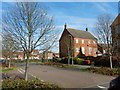
Langley - James Meadow
Large modern traditional style housing estate.
Image: © James Emmans
Taken: 25 Mar 2017
0.17 miles