IMAGES TAKEN NEAR TO
Wexham Woods, SLOUGH, SL3 6LQ
Introduction
This page details the photographs taken nearby to Wexham Woods, SL3 6LQ by members of the Geograph project.
The Geograph project started in 2005 with the aim of publishing, organising and preserving representative images for every square kilometre of Great Britain, Ireland and the Isle of Man.

There are currently over 7.5m images from over14,400 individuals and you can help contribute to the project by visiting https://www.geograph.org.uk
Image Map
Images are licensed for reuse under creativecommons.org/licenses/by-sa/2.0
Notes
- Clicking on the map will re-center to the selected point.
- The higher the marker number, the further away the image location is from the centre of the postcode.
Image Listing (10 Images Found)
Images are licensed for reuse under creativecommons.org/licenses/by-sa/2.0
Image
Details
Distance
1
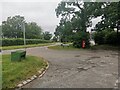
Wexham - Church Grove entrance from Church Lane
Image: © James Emmans
Taken: 19 Jun 2021
0.11 miles
2
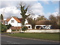
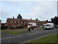
Houses in Church Lane, Stoke Green
Looking north-east across Church Lane by the school, just at the corner of the grid square
Image: © David Hawgood
Taken: 21 Feb 2006
0.18 miles
3
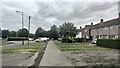
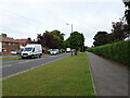
Norway Drive
An entrance to Wexham School is on the left.
Image: © James Emmans
Taken: 19 Jun 2021
0.20 miles
4
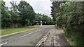
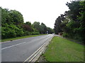
Wexham Park Lane
The turning for Wexham Park Hospital is on the Left.
Image: © James Emmans
Taken: 19 Jun 2021
0.20 miles
8
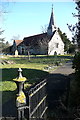
St Mary's church
Parts of the church date back to the 12th century. It feels a little odd to be standing here, looking at an old rural church, when behind me is the busy Church Lane and the suburban housing estates of Slough.
Image: © Graham Horn
Taken: 23 Feb 2012
0.22 miles
9
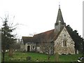
Wexham: St Mary's Church
The oldest part of the church, the nave, dates from the 12th century, and the circular opening in the west wall, visible here, dates from that time. Below it the two-light window dates from the 15th century. The bell tower has wooden weatherboarding and a wooden spire above.
The church appears to stand in isolation from any other contemporary buildings, but the manor house of Wexham Court, now demolished, used to stand on the other side of Church Lane. Today the Wexham Court housing estate covers the area of the manor house.
The church was formerly known as St Mary the Virgin and its website is here http://www.stmaryswexham.org.uk/
Image: © Nigel Cox
Taken: 8 Jan 2009
0.23 miles
10
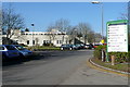
Wexham Park hospital
Taken from the car park at entrance 4 of the large hospital on the northern outskirts of Slough.
Image: © Graham Horn
Taken: 23 Feb 2012
0.25 miles