IMAGES TAKEN NEAR TO
Black Park Road, SLOUGH, SL3 6JJ
Introduction
This page details the photographs taken nearby to Black Park Road, SL3 6JJ by members of the Geograph project.
The Geograph project started in 2005 with the aim of publishing, organising and preserving representative images for every square kilometre of Great Britain, Ireland and the Isle of Man.

There are currently over 7.5m images from over14,400 individuals and you can help contribute to the project by visiting https://www.geograph.org.uk
Image Map
Images are licensed for reuse under creativecommons.org/licenses/by-sa/2.0
Notes
- Clicking on the map will re-center to the selected point.
- The higher the marker number, the further away the image location is from the centre of the postcode.
Image Listing (19 Images Found)
Images are licensed for reuse under creativecommons.org/licenses/by-sa/2.0
Image
Details
Distance
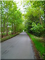
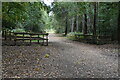
3

Beeches Way (67)
This is the way to go the next time.
To proceed to the next section of the Beeches Way go to http://www.geograph.org.uk/geotrips/592.
Image: © Shazz
Taken: 17 May 2013
0.11 miles
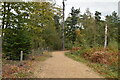
4
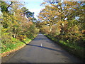
Fulmer: Black Park Road
Looking in the direction of Upton Farm.
Image: © Nigel Cox
Taken: 14 Nov 2007
0.14 miles
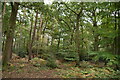
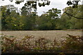
10
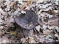
Fungus in Black Park, probably Russula nigricans
There was a big group of these fungi, brown, mushroom shaped with deep depression among oak leaves in Sycamore Wood. See Image for a view of gills and stem of another of this group
Image: © David Hawgood
Taken: 3 Sep 2017
0.17 miles