IMAGES TAKEN NEAR TO
Mathisen Way, SLOUGH, SL3 0FJ
Introduction
This page details the photographs taken nearby to Mathisen Way, SL3 0FJ by members of the Geograph project.
The Geograph project started in 2005 with the aim of publishing, organising and preserving representative images for every square kilometre of Great Britain, Ireland and the Isle of Man.

There are currently over 7.5m images from over14,400 individuals and you can help contribute to the project by visiting https://www.geograph.org.uk
Image Map
Images are licensed for reuse under creativecommons.org/licenses/by-sa/2.0
Notes
- Clicking on the map will re-center to the selected point.
- The higher the marker number, the further away the image location is from the centre of the postcode.
Image Listing (47 Images Found)
Images are licensed for reuse under creativecommons.org/licenses/by-sa/2.0
Image
Details
Distance
1
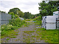
Track-bed, old Staines West branch
Looking south from Bath Road through a security fence. The line south from here closed in 1981, and was then severed by the M25 construction.
Image: © Robin Webster
Taken: 10 Jun 2017
0.13 miles
2
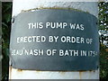
Poyle Pump - inscription on the pump
Supplemental to Image]
Image: © Roger W Haworth
Taken: 2 Aug 2003
0.14 miles
3
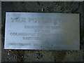
Poyle Pump - 1992 inscription near the pump
Supplemental to Image]
Image: © Roger W Haworth
Taken: 2 Aug 2003
0.14 miles
4
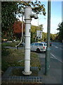
Poyle Pump
The Poyle Pump on the Bath Road, Poyle, between Poplar Close and Sherbourne Close. It stands nearly 3 metres tall. Inscriptions on or near the pump read:
'The Poyle Pump erected in 1827 by the Colnbrook Turnpike Trust. Restored in 1992. Contractor CDR Construction Ltd'
'This pump was erected by order of "Beau" Nash of Bath in 1754'
(The 1827 date is more likely - see this pump's mate Image)
Image: © Roger W Haworth
Taken: 2 Aug 2003
0.14 miles
5
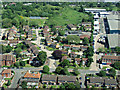
Poyle from the air
On approach to Heathrow from the west.
See also Image
Image: © Thomas Nugent
Taken: 19 May 2014
0.15 miles
6
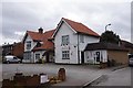
New Bettolo Italian Restaurant, Bath Road, Colnbrook
Image: © Ian S
Taken: 15 Mar 2020
0.16 miles
7
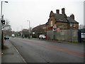
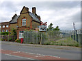
Poyle: Site of former Colnbrook railway station
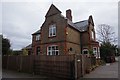
Colnbrook railway station was on the former Great Western Railway's branch line to Staines from its main line at West Drayton. It opened in 1884 and closed in 1965, occupying a site to the right of the photograph. It is thought by the photographer that the building with the Dutch gables was probably the stationmaster's house. The line crossed what was the main Bath Road here on its way south to Staines, but although the branch has been closed to passenger traffic for nearly 50 years, the railway north of here remains open as a freight line serving a fuel depot for Heathrow Airport. The end of this line is just beyond the steel security fence to the right, in the same place as shown on Ben's photograph of the scene from 1986 Image Extraordinarily, although no train has probably crossed over the road since 1965, and the rails have long since been lifted, the level crossing warning signs and traffic lights for road users, and on both sides of the road, visible in Ben's photograph, are still in situ!
The photograph was taken on a drear damp December day.
Image: © Nigel Cox
Taken: 12 Dec 2013
0.17 miles
8
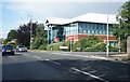
BancTec Ltd - Jarman House
On the corner of Poyle Road and Mathisen Way.
Image: © Fernweh
Taken: 29 May 2015
0.18 miles
9
End of line, Colnbrook
The former GWR line from West Drayton to Staines now ends here, at the former level crossing over Bath Road. The old station house on the left. The old level crossing with no gates signs survive on each side of the road, but with broken lights and rotated edge-on to the road.
Image: © Robin Webster
Taken: 10 Jun 2017
0.18 miles