IMAGES TAKEN NEAR TO
Chapel Lane, SLOUGH, SL2 4QL
Introduction
This page details the photographs taken nearby to Chapel Lane, SL2 4QL by members of the Geograph project.
The Geograph project started in 2005 with the aim of publishing, organising and preserving representative images for every square kilometre of Great Britain, Ireland and the Isle of Man.

There are currently over 7.5m images from over14,400 individuals and you can help contribute to the project by visiting https://www.geograph.org.uk
Image Map
Images are licensed for reuse under creativecommons.org/licenses/by-sa/2.0
Notes
- Clicking on the map will re-center to the selected point.
- The higher the marker number, the further away the image location is from the centre of the postcode.
Image Listing (29 Images Found)
Images are licensed for reuse under creativecommons.org/licenses/by-sa/2.0
Image
Details
Distance
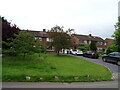
3
Houses East of Sefton Park
Taken from Farthing Green Lane - looking North East
Image: © Peter Ross
Taken: 8 Apr 2006
0.14 miles
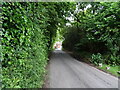
8
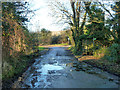
Damp spot on Hockley Lane
A small stream is crossed here.
Image: © Robin Webster
Taken: 19 Jan 2014
0.19 miles
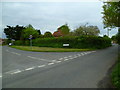
9
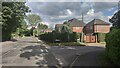
Hollybush Hill and turning into Allhusen Place
Image: © James Emmans
Taken: 25 Jun 2021
0.19 miles