IMAGES TAKEN NEAR TO
Park Road, SLOUGH, SL2 4PJ
Introduction
This page details the photographs taken nearby to Park Road, SL2 4PJ by members of the Geograph project.
The Geograph project started in 2005 with the aim of publishing, organising and preserving representative images for every square kilometre of Great Britain, Ireland and the Isle of Man.

There are currently over 7.5m images from over14,400 individuals and you can help contribute to the project by visiting https://www.geograph.org.uk
Image Map
Images are licensed for reuse under creativecommons.org/licenses/by-sa/2.0
Notes
- Clicking on the map will re-center to the selected point.
- The higher the marker number, the further away the image location is from the centre of the postcode.
Image Listing (7 Images Found)
Images are licensed for reuse under creativecommons.org/licenses/by-sa/2.0
Image
Details
Distance
2
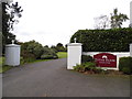
The entrance to Tithe Farm nursing home on Park Road
According to the maps this was an actual farm before the conversion.
Image: © David Howard
Taken: 4 Oct 2012
0.04 miles
3
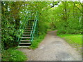
Viewing steps on the golf course
I have come the wrong way as usual. I hate golf courses. See Image
Image: © Shazz
Taken: 17 May 2013
0.16 miles
5
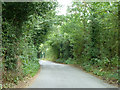
Parsonage Lane, Farnham Royal
The parsonage, actually mapped as a rectory, was some way further up the lane on the right.
Image: © Robin Webster
Taken: 13 Sep 2014
0.22 miles
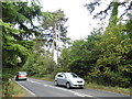
6
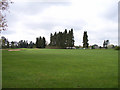
Farnham Park Golf Club
The clubhouse is behind the conifers.
Image: © Andrew Smith
Taken: 30 Apr 2006
0.22 miles
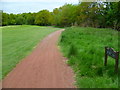
7
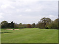
Farnham Park Golf Club
The southwest corner of the golf course.
Image: © Andrew Smith
Taken: 30 Apr 2006
0.23 miles