IMAGES TAKEN NEAR TO
Park Road, SLOUGH, SL2 4PD
Introduction
This page details the photographs taken nearby to Park Road, SL2 4PD by members of the Geograph project.
The Geograph project started in 2005 with the aim of publishing, organising and preserving representative images for every square kilometre of Great Britain, Ireland and the Isle of Man.

There are currently over 7.5m images from over14,400 individuals and you can help contribute to the project by visiting https://www.geograph.org.uk
Image Map
Images are licensed for reuse under creativecommons.org/licenses/by-sa/2.0
Notes
- Clicking on the map will re-center to the selected point.
- The higher the marker number, the further away the image location is from the centre of the postcode.
Image Listing (35 Images Found)
Images are licensed for reuse under creativecommons.org/licenses/by-sa/2.0
Image
Details
Distance
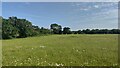
1
Gray's Field and Monument
A field run by the National trust. The area is called the Thomas Gray Landscape.
Image: © James Emmans
Taken: 23 Jun 2021
0.04 miles
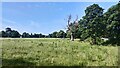
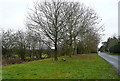
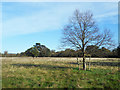
2

Dead Tree in Gray's Field
Still with the remains of its protective fence around it, a small tree which didn't last very long.
At the north end of Gray's Field, a meadow owned by the National Trust.
Image: © Des Blenkinsopp
Taken: 2 Nov 2018
0.06 miles
3
Field next to The Clock House
The grade II listed house can be seen in the tree.
Image: © James Emmans
Taken: 23 Jun 2021
0.06 miles
4
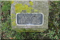
Queen Victoria's Jubilee Oak
The plaque indicates that an oak tree was planted here in 1887 to commemorate Queen Victoria's Golden Jubilee. This tree is a nearby replacement, following a road safety scheme at the junction in 1994. The context is here Image]
Image: © Graham Horn
Taken: 23 Feb 2012
0.09 miles
5
Trees on Church Lane
There is a plaque adjacent to the nearest tree indicating that it is a 1994 replacement for the Queen Victoria Golden Jubilee oak that was erected at the junction (behind me) by the children of Stoke Poges in 1887. The plaque is seen here Image]
Image: © Graham Horn
Taken: 23 Feb 2012
0.09 miles
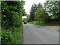
6
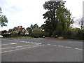
Church Lane at the junction of Park Road, Stoke Poges
Image: © David Howard
Taken: 4 Oct 2012
0.10 miles
7
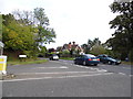
Church Lane at the junction of Park Road, Stoke Poges
Image: © David Howard
Taken: 4 Oct 2012
0.10 miles
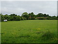
9
Gray's Field, Stoke Poges
Land acquired in the early 1920s by local people to preserve the environment around the monument to poet Thomas Gray. They presented it to the National Trust in 1925. https://www.nationaltrust.org.uk/features/grays-monument-and-grays-field-stoke-poges-buckinghamshire
Image: © Des Blenkinsopp
Taken: 2 Nov 2018
0.12 miles