IMAGES TAKEN NEAR TO
West End Lane, SLOUGH, SL2 4LZ
Introduction
This page details the photographs taken nearby to West End Lane, SL2 4LZ by members of the Geograph project.
The Geograph project started in 2005 with the aim of publishing, organising and preserving representative images for every square kilometre of Great Britain, Ireland and the Isle of Man.

There are currently over 7.5m images from over14,400 individuals and you can help contribute to the project by visiting https://www.geograph.org.uk
Image Map
Images are licensed for reuse under creativecommons.org/licenses/by-sa/2.0
Notes
- Clicking on the map will re-center to the selected point.
- The higher the marker number, the further away the image location is from the centre of the postcode.
Image Listing (13 Images Found)
Images are licensed for reuse under creativecommons.org/licenses/by-sa/2.0
Image
Details
Distance
1
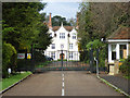
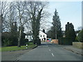
No Conferring
The former Bayer Group Conference Centre at Stoke Court looks like it has been closed for some time. This is by the entrance driveway. Even the estate agent's board has fallen over.
Image: © Des Blenkinsopp
Taken: 2 Nov 2018
0.09 miles
2
Stoke Court
The court is a now a Bayer Corporation conference centre.
Image: © Andrew Smith
Taken: 30 Apr 2006
0.09 miles
4
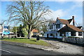
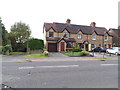
The Dog and Pot
This pub, on Rogers Lane, has closed recently. The "to let" sign suggests an uncertain future, although news reports http://www.sloughobserver.co.uk/news/roundup/articles/2012/02/15/57197-council-and-community-join-forces-to-save-pub/ suggest that the council and the community have joined forces to buy it and reopen it as a community hub. (Does that mean pub?) Meanwhile, there have been 26 offers on the property.
Image: © Graham Horn
Taken: 23 Feb 2012
0.12 miles
5
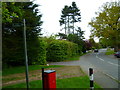
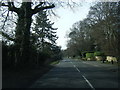
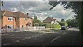
Rogers Lane, Stoke Poges
Junction with Duffield Lane.
Image: © Des Blenkinsopp
Taken: 2 Nov 2018
0.14 miles
8
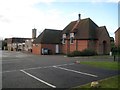
Stoke Poges: St Andrew's Church
St Andrew's Church on Rogers Lane is unusual in the sense that it was originally built in the 1920s/1930s as a Methodist Chapel, only to fall into disuse, and to be bought, along with its surrounding plot of land, by the established Church of England in the 1950s. It is the dark red brick building in the foreground. The existing church was then extended rearwards into the plot, with the evidently newer building in buff brickwork being completed.
Image: © Nigel Cox
Taken: 22 Dec 2013
0.23 miles